
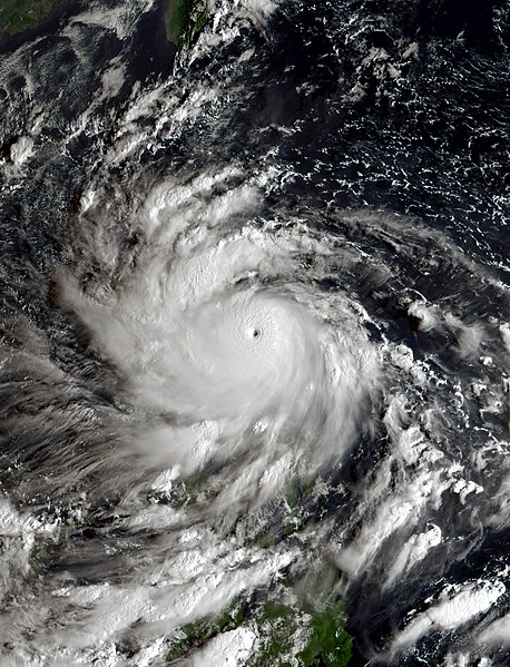
File:Noru 2022-09-24 2330Z.jpg

Size of this preview: 458 × 599 pixels. Other resolutions: 183 × 240 pixels | 367 × 480 pixels | 587 × 768 pixels | 783 × 1,024 pixels | 1,566 × 2,048 pixels | 2,600 × 3,400 pixels.
Original file (2,600 × 3,400 pixels, file size: 12.7 MB, MIME type: image/jpeg)
| This is a file from the Wikimedia Commons. Information from its description page there is shown below. Commons is a freely licensed media file repository. You can help. |
Summary
| Description |
English: This true-color image of Typhoon Noru (also known locally in the Philippines as Karding) was captured on September 24, 2022, at 23:30 UTC (7:30 AM Philippine Local Time on the next day), by the Advanced Himawari Imager (AHI) instrument flying aboard JMA's Himawari 8 satellite. Noru (Karding) was a small and powerful typhoon originating from a invest area east of the Philippines during 2022 Pacific typhoon season. When this image was captured, Noru (Karding) was approaching Luzon. Noru (Karding) would also impact Vietnam later in its track after crossing the South China Sea. When this was captured, Noru (Karding) was at its peak intensity as a Category 5 equivalent typhoon, with winds of 160 mph (260 km/h) (140 knots) on the 1-min Saffir-Simpson scale and winds of 110 mph (180 km/h) on the 10-min JMA typhoon scale making it a "very strong typhoon" on that scale, also when this image was taken it had a minimum central pressure of 940 mbar (27.8 inHg). |
| Date | |
| Source | AWS S3 Explorer |
| Author | JMA's Himawari 8 Satellite |
Licensing
This image was produced by the Japan Meteorological Agency. The legal notice (archive) stated that all the images published on their website is compatible with the Creative Commons Attribution 4.0 License, which means that all the images on this website is published under the Creative Commons Attribution 4.0 License unless otherwise specified.
This file is licensed under the Creative Commons Attribution 4.0 International license. Attribution: Japan Meteorological Agency
|
 |

File history
Click on a date/time to view the file as it appeared at that time.
| Date/Time | Thumbnail | Dimensions | User | Comment | |
|---|---|---|---|---|---|
| current | 22:59, 15 December 2022 | | 2,600 × 3,400 (12.7 MB) | TheWxResearcher | Increased the brightness slightly the water looked too black. But I'm not going to turn it up any further the brightness would be too unrealistic for that time of day. |
| 20:14, 14 December 2022 |  | 2,600 × 3,400 (11.98 MB) | TheWxResearcher | Uploaded a work by JMA's Himawari 8 Satellite from [https://noaa-himawari8.s3.amazonaws.com/index.html AWS S3 Explorer] with UploadWizard |
File usage
The following pages on the English Wikipedia use this file (pages on other projects are not listed):
Global file usage
The following other wikis use this file:
- Usage on es.wikipedia.org
- Usage on ko.wikipedia.org
- Usage on vi.wikipedia.org
- Usage on www.wikidata.org