
File:Prelucrare 3D pentru La Valletta Harbour.jpg

Size of this preview: 800 × 574 pixels. Other resolutions: 320 × 229 pixels | 640 × 459 pixels | 1,024 × 734 pixels | 1,280 × 918 pixels | 1,989 × 1,426 pixels.
Original file (1,989 × 1,426 pixels, file size: 1.49 MB, MIME type: image/jpeg)
| This is a file from the Wikimedia Commons. Information from its description page there is shown below. Commons is a freely licensed media file repository. You can help. |
Summary
| Description |
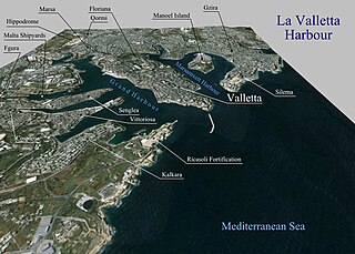
Română: Prelucrare 3D pentru La Valletta Harbour. |
| Date | |
| Source | Topographic data SRTM from NASA and World Imagery - NASA World Wind |
| Author | Asybaris01 |
Licensing
| This image is in the public domain because it is a screenshot from NASA’s globe software World Wind using a public domain layer, such as Blue Marble, MODIS, Landsat, SRTM, USGS or GLOBE.
|
 |
File history
Click on a date/time to view the file as it appeared at that time.
| Date/Time | Thumbnail | Dimensions | User | Comment | |
|---|---|---|---|---|---|
| current | 16:52, 6 September 2011 | | 1,989 × 1,426 (1.49 MB) | Asybaris01 | {{Information |Description ={{ro|1=Prelucrare 3D pentru La Valletta Harbour.}} |Source =Topographic data SRTM from NASA and World Imagery - NASA World Wind |Author =Asybaris01 |Date =sep 2011 |Permission |
File usage
The following pages on the English Wikipedia use this file (pages on other projects are not listed):
Global file usage
The following other wikis use this file:
- Usage on ar.wikipedia.org
- Usage on be-tarask.wikipedia.org
- Usage on ca.wikipedia.org
- Usage on co.wikipedia.org
- Usage on el.wikipedia.org
- Usage on fa.wikipedia.org
- Usage on fr.wikipedia.org
- Usage on hy.wikipedia.org
- Usage on it.wikipedia.org
- Usage on ja.wikipedia.org
- Usage on ka.wikipedia.org
- Usage on mr.wikipedia.org
- Usage on no.wikipedia.org
- Usage on pl.wikipedia.org
- Usage on ru.wikipedia.org
- Usage on sq.wikipedia.org
- Usage on zh.wikipedia.org