
Grand Harbour
| Grand Harbour | |
|---|---|
 The Grand Harbour from above | |
 Click on the map for a fullscreen view | |
| Location | |
| Country | Malta |
| Location | Southern Harbour Area |
| Details | |
| Type of harbour | coastal natural |
| Size of harbour | 2,035,000 square metres (503 acres) |
| Maximum Length | 3.63 kilometres (2.26 mi) |
| Maximum Width | 1.33 kilometres (0.83 mi) |
| Average Depth | 7.7 metres (25 ft) |
This article includes a list of general references, but it lacks sufficient corresponding inline citations. (June 2021) |
The Grand Harbour (
Description


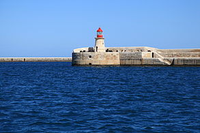
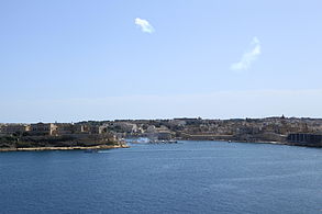
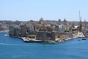
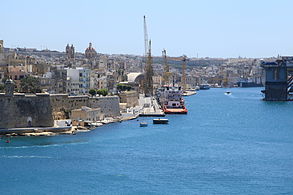
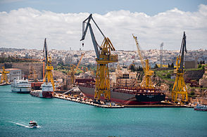
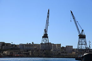
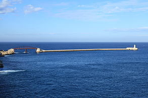
The harbour mouth faces north east and is bounded to the north by Saint Elmo Point and further sheltered by an isolated breakwater and is bounded to the south by Ricasoli Point. Its north west shore is formed by the Sciberras peninsula, which is largely covered by the city of Valletta and its suburb Floriana. This peninsula also divides Grand Harbour from a second parallel natural harbour, Marsamxett Harbour. The main waterway of Grand Harbour continues inland almost to Marsa. The southeastern shore of the harbour is formed by a number of inlets and headlands, principally Rinella Creek, Kalkara Creek, Dockyard Creek, and French Creek, which are covered by Kalkara and the Three Cities: Cospicua, Vittoriosa, and Senglea. The harbour has been described as Malta's greatest geographic asset.[3]
With its partner harbour of Marsamxett, Grand Harbour lies at the centre of gently rising ground. Development has grown up all around the twin harbours and up the slopes so that the whole bowl is effectively one large conurbation. Much of Malta's population lives within a three kilometer radius of Floriana. This is now one of the most densely populated areas in Europe. The harbours and the surrounding areas make up Malta's Northern and Southern Harbour Districts. Together, these districts contain 27 of 68 local councils. They have a population of 213,722 which make up over 47% of the total population of the Maltese islands.[4]
History

The Maltese islands have a long history, mainly due to their strategic location and natural harbours, mainly the Grand Harbour as well as Marsamxett. The Grand Harbour has been used since prehistoric times.
Megalithic remains have been found on the shores of the Grand Harbour. The
By the 12th and 13th centuries, the
In 1283, the Battle of Malta was fought at the entrance of the Grand Harbour. Aragonese forces defeated a larger Angevin force and captured 10 galleys.[8]
The Grand Harbour was the base for the
Later on in the 1550s, a
The area was the scene of much of the fighting in the Great Siege of Malta of 1565 when the Ottomans attempted to eject the Order of St John but were ultimately defeated. After the siege, the capital city of Valletta was built on the Sciberras peninsula on the north west shore of the harbour. Over the years, more fortifications and settlements were founded within the Grand Harbour, including Fort Ricasoli and the towns of Floriana and Cospicua.

_-_n._1968_-_Grand_Harbour_-_Malta.jpg)
During the

The whole area was savagely bombed during the

In September 2007, the
As of May 2021 the harbour is undergoing renovation works initiated by
Around the Grand Harbour from Fort Ricasoli to Fort St. Elmo


- Fort Ricasoli
- Rinella Bay
- Bighi
- Kalkara Creek
- Fort St. Angelo
- Dockyard Creek or Cottonera Marina
- St. Angelo Strand, Birgu
- Xatt il-Forn, Birgu
- Xatt ir-Risq, Birgu
- Xatt San Lawrenz, Birgu
- Bormla
- Xatt Juan B. Azzopardi, Senglea
- Fort Saint Michael
- French Creek
- Dock No. 2
- Ghajn Dwieli Road
- Corradino
- Dock No. 6
- Ras Ħanżir Point
- New Port
- Shipwrights Wharf, Paola
- Dock No. 7
- Xatt il-Mollijiet, Albert Town
- Church Wharf, Marsa
- Il-Menqa
- Bridge Wharf, Marsa
- Flagstone Wharf / Moll iċ-Ċangatura, Marsa
- Lighters Wharf / il-Moll tal-Braken, Marsa
- Timber Wharf / il-Moll tal-Ħatab, Marsa
- Xatt l-Għassara tal-Għeneb, Marsa
- Valletta Waterfront or Pinto Wharf, Floriana
- Lascaris Wharf,[12] Valletta
- Xatt il-Barriera, Valletta
- Taħt iż-Żiemel
- Fort St. Elmo
Gallery

-
 Ricasoli Breakwater
Kalkara -
 Fort Ricasoli
Kalkara -
 Bighi
Bighi
Kalkara -
 Kalkara Creek
Kalkara and Birgu -
 Fort Saint Angelo
Birgu -
 The Spur
Senglea -
 French Creek
Senglea, Cospicua and Paola -
 Dock No. 4
Cospicua -
 Dock No. 6 (China Dock)
Cospicua -
 Shipwrights Wharf
Paola and Marsa -
 Bridge Wharf and Marsa Power Station
Marsa -
 Braken Wharf
Marsa -
 Xatt Lascaris
Valletta -
 Fort Saint Elmo
Valletta -
 St. Elmo Bridge
Valletta -
 Valletta Breakwater
Valletta
_03_ies.jpg)


_01_ies.jpg)
_01_ies.jpg)
_01_ies.jpg)
_01_ies.jpg)
_01_ies.jpg)

_01_ies.jpg)

_02_ies.jpg)
_01_ies.jpg)

_07_ies.jpg)
_01_ies.jpg)
See also
References
- ^ "Port of Valletta". Transport Malta. Archived from the original on 31 May 2016. Retrieved 5 November 2014.
- OCLC 870266285.
- ^ Agius, Raymond. "The Grand Harbour in Malta". agius.com. Retrieved 5 November 2014.
- ^ "Estimated Population by Locality 31st March, 2013" (PDF). Malta Government Gazette 19,094. Archived from the original (PDF) on 14 July 2014. Retrieved 31 October 2014.
- ^ ISBN 9993239879.
- ^ Coppens, Philip. "Malta: the small island of the giants". philipcoppens.com. Retrieved 2 May 2015.
- ^ "Fort St Angelo". Lonely Planet. Retrieved 5 November 2014.
- ^ Said, Frans (30 June 2013). "The Battle of Malta 730 years ago". Times of Malta. Retrieved 5 November 2014.
- ^ Bugeja, Lino (11 August 2013). "The historical importance of Malta's Grand Harbour". Times of Malta. Retrieved 31 October 2014.
- ^ "Government's Vision for Grand Harbour will generate jobs and investment – MEA". The Malta Independent. 8 September 2007. Retrieved 5 November 2014.
- ^ "Cavotec Wins Cleantech Contract to Cut Ship Emissions". Manufacturing and Engineering Magazine. 18 May 2021. Retrieved 19 May 2021.
- ^ Caruana Dingli, Petra (2018). The Waterside of Valletta: Grand Masters, Travellers and Military Men. Encounters with Valletta: A Baroque City Through the Ages: University of Malta. p. 213–227.