
File:Prusy Wschodnie de.svg

Size of this PNG preview of this SVG file: 499 × 599 pixels. Other resolutions: 200 × 240 pixels | 399 × 480 pixels | 639 × 768 pixels | 852 × 1,024 pixels | 1,705 × 2,048 pixels | 596 × 716 pixels.
Original file (SVG file, nominally 596 × 716 pixels, file size: 53 KB)
| This is a file from the Wikimedia Commons. Information from its description page there is shown below. Commons is a freely licensed media file repository. You can help. |
| Description |
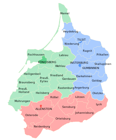
Deutsch: Verwaltungsgliederung der Provinz Ostpreußen in Stadt- und Landkreise nach der Schaffung des Regierungsbezirks Allenstein am 1. November 1905:
Regierungsbezirk Königsberg
Regierungsbezirk Gumbinnen
Regierungsbezirk Allenstein Polski: Podział administracyjny Prus Wschodnich na rejencje i powiaty.
English: Adiministrative divisions of the province of East Prussia after 1905 (establishment of Regierungsbezirk Allenstein) |
| Date | (UTC) |
| Source | |
| Author |
|
| This is a retouched picture, which means that it has been digitally altered from its original version. Modifications: Deutsche Übersetzung / German translation. The original can be viewed here: Prusy Wschodnie.svg:
|
I, the copyright holder of this work, hereby publish it under the following license:
This file is licensed under the Creative Commons Attribution-Share Alike 2.5 Generic license.
- You are free:
- to share – to copy, distribute and transmit the work
- to remix – to adapt the work
- Under the following conditions:
- attribution – You must give appropriate credit, provide a link to the license, and indicate if changes were made. You may do so in any reasonable manner, but not in any way that suggests the licensor endorses you or your use.
- share alike – If you remix, transform, or build upon the material, you must distribute your contributions under the same or compatible license as the original.
Original upload log
This image is a derivative work of the following images:
- File:Prusy_Wschodnie.svg licensed with Cc-by-sa-2.5
- 2010-06-05T12:26:27Z Poznaniak 750x990 (77308 Bytes) {{Information |Description=Podział administracyjny [[:pl:Prusy Wschodnie|Prus Wschodnich]] na rejencje i powiaty |Source=własna praca |Date=05.06.2010 |Author=[[user:Poznaniak|Poznaniak]] |Permission={{cc-by-sa-2.5}} }} [[
Uploaded with derivativeFX
File history
Click on a date/time to view the file as it appeared at that time.
| Date/Time | Thumbnail | Dimensions | User | Comment | |
|---|---|---|---|---|---|
| current | 15:59, 3 April 2015 | | 596 × 716 (53 KB) | Furfur | Kreis Barten -> Kreis Friedland |
| 11:03, 25 March 2012 |  | 596 × 716 (267 KB) | Furfur | Bild etwas verkleinert, Schriften in Konturen | |
| 12:04, 2 September 2010 |  | 750 × 990 (54 KB) | Furfur | Elchniederung -> Niederung (Umbenennung erfolgt erst 1938) | |
| 21:55, 15 August 2010 |  | 750 × 990 (54 KB) | Furfur | {{Information |Description={{de|Verwaltungsgliederung der Provinz Ostpreußen in Stadt- und Landkreise nach der Schaffung des Regierungsbezirks Allenstein am 1. November 1905.}} {{pl|Podział admini |
File usage
The following pages on the English Wikipedia use this file (pages on other projects are not listed):
Global file usage
The following other wikis use this file:
- Usage on ba.wikipedia.org
- Usage on de.wikipedia.org
- Usage on fr.wikipedia.org
- Usage on gl.wikipedia.org
- Usage on it.wikipedia.org
- Usage on lt.wikipedia.org
- Gumbinės apygarda
- Įsruties apskritis
- Karaliaučiaus apygarda
- Girdavos apskritis
- Ylavos apskritis
- Labguvos apskritis
- Vėluvos apskritis
- Šventapilės apskritis
- Frydlando apskritis
- Heilsbergo apskritis
- Karaliaučiaus kaimiškoji apskritis
- Pilkalnio apskritis
- Ragainės apskritis
- Tilžės apskritis
- Tilžės-Ragainės apskritis
- Alnaštyno apskritis
- Braunsbergo apskritis
- Morungo apskritis
- Neidenburgo apskritis
- Ortelsburgo apskritis
- Osterodės apskritis
- Prūsų Olandijos apskritis
- Rastenburgo apskritis
- Rešliaus apskritis
- Alnaštyno apygarda
- Johanisburgo apskritis
- Zensburgo apskritis
- Lėciaus apskritis
- Luko apskritis (Prūsija)
- Unguros apskritis
- Alėckos apskritis
- Usage on no.wikipedia.org
- Usage on ru.wikipedia.org
View more global usage of this file.