
File:Russian Occupation of Kherson Oblast.svg

Original file (SVG file, nominally 1,430 × 1,048 pixels, file size: 649 KB)
| This is a file from the Wikimedia Commons. Information from its description page there is shown below. Commons is a freely licensed media file repository. You can help. |
Summary

|
This file may be updated to reflect new information. If you wish to use a specific version of the file without new updates being mirrored, please upload the required version as a separate file. |
| Description |
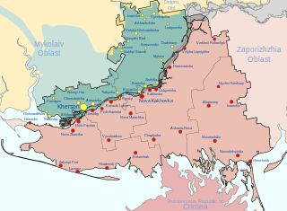
Русский: Заявленная ( , — деоккупированная) территория Херсонской военно-гражданской администрации, совпадающая с территорией Херсонской области Украины, и контролируемая ХВГА территория ( )
English: Claimed ( , — deoccupied) territory of Russia's Khersonskaya Oblast (not including the environs of Snihurivka), coinciding with the territory of Kherson Oblast in Ukraine, and dependent territory of Khersonskaya Oblast ( )
Français : territoire revendiqué ( , — déoccupé) de l'administration militaro-civile de Kherson, coïncidant avec le territoire de la région de Kherson en Ukraine, et territoire dépendant du AMCK ( ) |
| Date | 27 August 2022 (first version) |
| Source |
Own work, derivate of Viewsridge, Kherson in Ukraine (claims hatched).svg by TUBS, & Kherson military–civilian administration.png by Тыченко
|
| Author |
Physeters |
| Other versions |
[]
|


.png)


.png)


.svg)
This file is translated using SVG <switch> elements. All translations are stored in the same file! Learn more.
For most Wikipedia projects, you can embed the file normally (without a To translate the text into your language, you can use the Graphics Lab if you're not sure how to do this.
|
Licensing
- You are free:
- to share – to copy, distribute and transmit the work
- to remix – to adapt the work
- Under the following conditions:
- attribution – You must give appropriate credit, provide a link to the license, and indicate if changes were made. You may do so in any reasonable manner, but not in any way that suggests the licensor endorses you or your use.
- share alike – If you remix, transform, or build upon the material, you must distribute your contributions under the same or compatible license as the original.
File history
Click on a date/time to view the file as it appeared at that time.
| Date/Time | Thumbnail | Dimensions | User | Comment | |
|---|---|---|---|---|---|
| current | 08:44, 16 January 2024 | | 1,430 × 1,048 (649 KB) | Physeters | remove Kakhovka Reservoir |
| 22:19, 15 January 2024 |  | 1,430 × 1,048 (477 KB) | Physeters | Updates per the ISW, add Bilohrudove, Pishchanivka, Kozachi Laheri and Krynky | |
| 05:57, 31 August 2023 |  | 1,430 × 1,048 (464 KB) | Physeters | the flooding completely subsided months ago | |
| 21:17, 1 July 2023 |  | 1,430 × 1,048 (486 KB) | Semyon 'dicto' Fedotov | fixed typo, removed unnecessary accents | |
| 06:52, 16 June 2023 |  | 1,430 × 1,048 (486 KB) | Physeters | update flooding and control of Oleshky per the ISW | |
| 21:13, 8 June 2023 |  | 1,430 × 1,048 (478 KB) | Physeters | Clean up flooded areas; make flooded areas grey, since they are most likely controlled by neither side at this time | |
| 18:52, 8 June 2023 |  | 1,430 × 1,048 (469 KB) | Nahabino | Update. | |
| 11:58, 8 June 2023 |  | 1,430 × 1,048 (470 KB) | Nahabino | Update. | |
| 14:07, 7 June 2023 |  | 1,430 × 1,048 (470 KB) | Nahabino | minor fixes | |
| 14:03, 7 June 2023 |  | 1,430 × 1,048 (469 KB) | Nahabino | Update with possible water flow. |
File usage
Global file usage
The following other wikis use this file:
- Usage on ar.wikipedia.org
- Usage on be.wikipedia.org
- Usage on ca.wikipedia.org
- Usage on cs.wikipedia.org
- Usage on de.wikipedia.org
- Usage on es.wikipedia.org
- Usage on et.wikipedia.org
- Usage on fr.wikipedia.org
- Usage on he.wikipedia.org
- Usage on hu.wikipedia.org
- Usage on id.wikipedia.org
- Usage on it.wikipedia.org
- Usage on ja.wikipedia.org
- Usage on lmo.wikipedia.org
- Usage on lv.wikipedia.org
- Usage on pl.wikipedia.org
- Usage on pt.wikipedia.org
- Usage on ru.wikipedia.org
- Usage on uk.wikipedia.org
- Usage on www.wikidata.org
- Usage on zh.wikipedia.org