
File:View up main ramp from Santa Barbara Bastion - Castillo de San Felipe del Morro, Northwest end of San Juan, San Juan, San Juan Municipio, PR HABS PR,7-SAJU,6-27.tif

Size of this JPG preview of this TIF file: 800 × 570 pixels. Other resolutions: 320 × 228 pixels | 640 × 456 pixels | 1,024 × 730 pixels | 1,280 × 912 pixels | 2,560 × 1,825 pixels | 5,000 × 3,564 pixels.
Original file (5,000 × 3,564 pixels, file size: 17 MB, MIME type: image/tiff)
| This is a file from the Wikimedia Commons. Information from its description page there is shown below. Commons is a freely licensed media file repository. You can help. |
Summary
| View up main ramp from Santa Barbara Bastion - Castillo de San Felipe del Morro, Northwest end of San Juan, San Juan, San Juan Municipio, PR
( |
||||||||||||||||||||||||||
|---|---|---|---|---|---|---|---|---|---|---|---|---|---|---|---|---|---|---|---|---|---|---|---|---|---|---|
| Photographer |
|
|||||||||||||||||||||||||
| Title |
View up main ramp from Santa Barbara Bastion - Castillo de San Felipe del Morro, Northwest end of San Juan, San Juan, San Juan Municipio, PR |
|||||||||||||||||||||||||
| Description |
Antonelli, Juan Baustista; de Salazar, Pedro; Price, Gigi B, transmitter; Klugh, T, transmitter; Behrens, Tom, transmitter; Boucher, Jack E, photographer; Price, Virginia B, transmitter |
|||||||||||||||||||||||||
| Depicted place | Puerto Rico; San Juan Municipio; San Juan | |||||||||||||||||||||||||
| Date | 1960 | |||||||||||||||||||||||||
| Dimensions | 5 x 7 in. | |||||||||||||||||||||||||
| Current location |
Library of Congress Prints and Photographs Division Washington, D.C. 20540 USA http://hdl.loc.gov/loc.pnp/pp.print |
|||||||||||||||||||||||||
| Accession number |
HABS PR,7-SAJU,6-27 |
|||||||||||||||||||||||||
| Credit line |
|
|||||||||||||||||||||||||
| Notes |
|
|||||||||||||||||||||||||
| References |
|
|||||||||||||||||||||||||
| Source | https://www.loc.gov/pictures/item/pr0076.photos.143940p | |||||||||||||||||||||||||
| Permission (Reusing this file) |
|
|||||||||||||||||||||||||

File history
Click on a date/time to view the file as it appeared at that time.
| Date/Time | Thumbnail | Dimensions | User | Comment | |
|---|---|---|---|---|---|
| current | 10:58, 1 August 2014 | 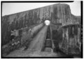 | 5,000 × 3,564 (17 MB) | Fæ | GWToolset: Creating mediafile for Fæ. HABS 31 July 2014 (3000:3200) |
File usage
The following pages on the English Wikipedia use this file (pages on other projects are not listed):