
Fishergate
| Fishergate | |
|---|---|
North Yorkshire | |
| Ambulance | Yorkshire |
| UK Parliament | |
Fishergate is a street and surrounding area of York, England.
History
Fishergate runs along a strip of slightly raised ground, east of the
In the 12th century, St Andrew's Priory was constructed to the west of Fishergate. Following the
Layout and architecture
The street runs south-east from the River Foss at Castle Mills Bridge, as the continuation of Tower Street. It turns south and continues until it becomes Fulford Road, at its junction with New Walk Terrace and Grange Garth. On its east side, it has junctions with Piccadilly, Paragon Street, Kent Street, Escrick Terrace, Escrick Street, Melbourne Street and Winterscale Street, while on its west side, it has junctions with Oxtoby Court, Fewster Way, Blue Bridge Lane, Marlborough Grange and Sandringham Street. The street forms part of the A1036, and its section from Castle Mills Bridge to Escrick Terrace is part of the inner ring road, with the section from Paragon Street to Escrick Terrace is open to northbound traffic only.
Notable buildings on the east side street include part of the city walls; The Edinburgh Arms pub, built as a house in 1830;[6] 29 Fishergate, a late 18th-century building which served for a time as the Nunnery of the Sisters of St Vincent;[7] the early-19th century Ivy Cottage;[8] and Fishergate County Primary School, built in 1893 by W. H. Brierley.[9] On the west side lie The Masons Arms, a pub built in 1935 to a design by James Knight;[10] 16–40 Fishergate, a terrace built in 1830;[7] an early-21st century bingo hall;[2] and the Lighthorseman Hotel, a pub built about 1870.[11] Fishergate House, built in 1837 by J. B. and William Atkinson, formerly had an address on the street but is now said to lie on Blue Bridge Lane.[7]
Ward
In the
Gallery
-
 Fishergate Primary School
 -
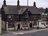
 The Lighthorseman
 -
 The Edinburgh Arms
 -
 The Masons Arms


References
- ^ a b c "Character area 66: Fishergate-River Ouse". City of York Council. Retrieved 14 June 2021.
- ^ a b c "Character area 18: Fishergate". City of York Council. Retrieved 15 June 2021.
- ISBN 978-0-582-29906-1.
- ISBN 1874454213.
- ^ "Digging for Britain – Series 10: 6. Ice Age Camp and a Saint with Syphilis". Retrieved 6 May 2023.
- ^ Historic England. "The Edinburgh Arms (1257839)". National Heritage List for England. Retrieved 15 June 2021.
- ^ a b c An Inventory of the Historical Monuments in the City of York. Vol. 4. London: Her Majesty's Stationery Office. 1975. Retrieved 28 September 2020.
- ^ Historic England. "Ivy Cottage (1257842)". National Heritage List for England. Retrieved 15 June 2021.
- ^ Historic England. "Fishergate County Primary School (1257844)". National Heritage List for England. Retrieved 15 June 2021.
- ^ Historic England. "The Masons Arms (1257836)". National Heritage List for England. Retrieved 15 June 2021.
- ^ Historic England. "The Lighthorseman Hotel (1257803)". National Heritage List for England. Retrieved 15 June 2021.
- Office for National Statistics. Retrieved 15 June 2021.