
Foots Cray Meadows


Foots Cray Meadows is an area of parkland and woodland 97 hectares (240 acres) in size, within the
The Meadows are a
History
The area was originally a part of the Foots Cray Place estate, and during the 18th century the Five Arches bridge was built. At the same time, an almshouse was built adjacent to the woods, which, as of 2008, was being excavated by archaeologists belonging to Bexley Archaeological Group. Bexley Archaeological Group
On 18 October 1949 Foots Cray Place caught fire and the house was destroyed.[citation needed] The ruins were subsequently demolished and the grounds became Foots Cray Meadows, a public park.
In the early 2000s, Five Arches bridge was renovated with new stone, along with the 'Penny Farthing' bridge just upstream.[6]
Gallery
-
 Foots Cray Meadows
 -
 Lake in Foots Cray Meadows
 -
 River Cray in Foots Cray Meadows
 -

-
 The 18th century Five Arches bridge after its renovation in the 2000s
 -
 Five Arches in winter
 -
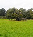 Sweet chestnut tree at the Meadows, one of the oldest documented trees in the region
 -
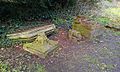 Fallen masonry


References
- ^ London Borough of Bexley, Bexley Civic Offices (19 March 2009). "Foots Cray Meadows". Archived from the original on 2016-08-12. Retrieved 29 October 2016.
- ^ "Foots Cray Meadows". Local Nature Reserves. Natural England. 4 March 2013. Archived from the original on 2 February 2014. Retrieved 22 January 2014.
- ^ "Map of Foots Cray Meadows". Local Nature Reserves. Natural England. Retrieved 22 January 2014.
- ^ "The River Cray". Greenspace Information for Greater London. 2006. Archived from the original on 24 December 2012. Retrieved 8 September 2012.
- ^ London Borough of Bexley, Bexley Civic Offices (19 March 2009). "Foots Cray Meadows". Archived from the original on 2016-08-12. Retrieved 29 October 2016.
- ^ A History of Foots Cray Place Archived 2009-04-15 at the Wayback Machine
Copies of A History of Footscray can be purchased from Bexley Archaeological Group Bexley Archaeological Group
Bibliography
- Dunning, G. C. (1959). "Medieval Discoveries at Cray House, Bexley" (PDF). Archaeologia Cantiana. 73: 211–213.