
Fort Granger
Fort Granger | |
 Fort Granger's earthworks | |
  | |
| Location | 113 Fort Granger Franklin, TN 37065 Franklin, Tennessee |
|---|---|
| Coordinates | 35°55′33″N 86°51′38″W / 35.92583°N 86.86056°W |
| Area | 20 acres (8.1 ha) |
| Built | 1862 |
| NRHP reference No. | 73001858[1] |
| Added to NRHP | January 8, 1973 |
Fort Granger was a Union fort built in 1862 in
Today, Fort Granger's remaining earthworks are preserved within a city park that is located near the center of Franklin. Fort Granger is listed on the National Register of Historic Places.[2] The site is accessible to the public via a trail from Pinkerton Park. Its grounds include a boardwalk offering a view of the Harpeth River and extending through part of the fort's site.[2]
History
As a fort
Construction, early use
After the
Fort Granger was built on Figuer's Bluff, north of the Harpeth River and parallel to the railroad to Nashville.[6] Siting it on the bluff enabled strategic military control over the Harpeth River bridge of the Tennessee and Alabama Railroad. The fort also had control over the southern and northern approaches to Franklin.[7]
The completed fort comprised nearly 275,000 square feet.[6] It is approximately 781 feet long and 346 wide.[8] Its entrance was called the "sally port."[7] The strongest part of the fortification, called "The Cavalier," was the location where the ground was the highest.[9] This "fort within a fort" was meant for use during overpowering attacks where defenders could make a final stand against invaders.[9] The Cavalier was ideal for artillery because it provided the best view of the surrounding landscape.[9]
Union troops and some refugee contraband slaves built Fort Granger.[10] James L. Rogers, 98th Ohio Infantry, wrote a letter dated June 4, 1863 that lists some of the Federal units who constructed Fort Granger. Rogers said,
"For the last 2 months and over we have been camped in, near Franklin, Tenn.. While our stay there, our time was principally occupied in working on the fortifications and scouting occasionally. And on the 2nd day of June General Grainger’s commenced including the 125th.O., 124th., O, 113th., O., 121st.O., 98th.O., 40th.O., 115th.ILL., 96th., ILL., 12ILL., & 84th Ind., and 2 or 3 regts of cavalry & 3 battries left Franklin at 6 a.m."[11]
The Samuel Boyd Map shows the positions of the Federal unit's camp sites at Franklin in 1863.[12]
The Union position in Franklin was initially secure, and Fort Granger had only a small garrison.[6] Union troops hanged two Confederate spies on June 9, 1863.[6] The fort's artillery was used twice in 1863 against Confederate cavalry forces.[3]
During the Second Battle of Franklin
Fort Granger's most important time came during the
Fort Granger served the Union cause. In the late afternoon of November 30, 1864, Confederate General John Bell Hood's army attacked Union General John M. Schofield's troops in a fierce battle. The fighting lasted for five hours, including widespread hand-to-hand combat and artillery fire, causing 10,000 casualties on both sides.[10] Union General Schofield commanded Union forces from inside the fort,[6] where he had an excellent view of the battlefield.[10] At the same time, he ordered his men to build pontoon bridges across the Harpeth River, permitting the movement of supply wagons and troops to Nashville once the battle had ended.[10]
Fort Granger's artillery delivered enfilading fire upon Confederate attackers on November 30, 1864.[14] Four 3-inch rifled cannons in Fort Granger were fired by Capt. Giles J. Cockerill, Battery D, 1st Ohio Light Artillery.[13] The Confederates suffered serious casualties under the 163 rounds fired by Cockerill's guns.[13] The right wing of the Confederate line, commanded by Gen. A. P. Stewart's corps, suffered the most from these rounds.[13] Confederate attackers were subject to massed fire from the Union artillery from the fort.[15] Local topography made Fort Granger's fire all the more lethal. When Confederate General Stewart's men advanced under fire, their right flank was blocked by the Harpeth River. Confederate infantry regiments such as the 35th Alabama and the 12th Louisiana, General Thomas Scott's brigade, and the 43rd Mississippi, Gen. John Adams' brigade, were in particular had numerous casualties. Stewart's Corps suffered almost 3,000 casualties during the battle.[10]
German immigrant and Union Lieutenant
Condition in 1864-5
In 1864, James Willett found the fort to be in a "dilapidated condition" and noted that "no efforts had been made to keep it in proper order or repair." He noted further that the "magazines [were] very damp and entirely unfit to store ammunition." He further "noticed green mold on the ceiling." "The heavy guns," he noted, "were being remounted"; Willett believed that "the intention was to keep two field pieces in the fort."Lamont, ed. (1891). The War of the Rebellion, Series I, Vol XXXII, Part III - Correspondence. Washington: Government Printing office. p. 332. By June 1865, the fort's was inspected under the authority of Maj Gen
As a historical site
In 1973, a 20-acre (8.1 ha) area designated as the Fort Granger site, which included one
The site now contains several historical panels about the fort's history and the events surrounding its construction and use.Gallery
-
 View of fort site from the bottom of the trail
 -
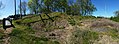
 Fort Granger earthworks
 -
 View of earthworks and observation deck
 -
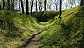
 View of trail leading up to fort
 -
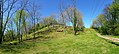
 Center of the Fort Granger site
 -


See also
- Franklin Battlefield
- Winstead Hill, also NRHP-listed within the Franklin Battlefield area
- Carnton, also NRHP-listed in the battlefield
- Fountain Carter House, also NRHP-listed in the battlefield
- Roper's Knob Fortifications, another NRHP-listed fortification on the Franklin battlefield area
References
- ^ a b "National Register Information System". National Register of Historic Places. National Park Service. March 13, 2009.
- ^ a b "Fort Granger". www.franklin-gov.com. Retrieved 10 July 2016.
- ^ a b c "Fort Granger". Historical marker, 113 Fort Granger Dr, Franklin, TN 37064
- ISBN 978-0-313-39234-4.
- ^ Holladay, Bob (Spring 2009). "Review: James Hogan, Jr., and the Conflicts of Antebellum Southern Identity in Williamson County". Tennessee Historical Quarterly: 20–39.
- ^ a b c d e Jacobson, pp. 208-12; Welcher, p. 593; Sword, p. 167; Eicher, p. 772.
- ^ a b "Battlefield Tours Fort Granger". Civil War Landscapes. December 26, 2010. Retrieved March 24, 2015.
- ^ McNutt, Kraig W. (2014). Who Built Fort Granger?. The Center for the Study of the Civil War.
- ^ a b c "The Cavalier". Civil War Journeys. Retrieved 24 March 2015.
- ^ a b c d e f Historical marker: "We could see every troop and every gun," located at Fort Granger
- ^ The Kraig McNutt Civil War Collection, https://battleoffranklin.wordpress.com/about-your-guide/
- ^ The Fortress War: Effect of Union Fortifications in the Western Theater of the American Civil War, by Thomas R. Flagel. Middle Tennessee State University, 2016. Doctoral dissertation. p 44.
- ^ a b c d e Dover, Michael (March 24, 2011). "The Historical Marker Database". The Historical Marker Database. Retrieved March 24, 2015.
- ^ Jacob Dolson Cox (1897). The Battle of Franklin, Tennessee, November 30, 1864: a monograph. New York: C. Scribner's Sons. p. 123. Retrieved 10 July 2016.
- ^ Crownover, Sims (December 1955). "The Battle of Franklin". Tennessee Historical Quarterly.
- ^ Jack Morgan and Earle DuRard, Jr. (September 1, 1972). "National Register of Historic Places Inventory/Nomination: Fort Granger". National Park Service. Retrieved March 2, 2017. with two photos from 1973 and aerial photo from 1972
External links
- Fort Granger - City of Franklin
- Virtual tour of Fort Granger - Stop #5
| Topics | |
|---|---|
| Lists by state |
|
| Lists by insular areas | |
| Lists by associated state | |
| Other areas | |
| Related | |