
Frideswide Square

Frideswide Square is a
St Frideswide
.
The "square" is actually more of a tapered rectangle in shape. Immediately to the north, the modern
A4144 road) act as an inner ring road leading to Abingdon Road, the main arterial road south out of the city. On the corner with Hollybush Row is the old Frank Cooper's jam factory, now used as office space for Nuffield College and a restaurant.[2][3] To the west, Botley Road (A420 road) leads out of the city centre, under a railway bridge just south of the main Oxford railway station
, situated to the northwest.
The square is a major traffic hub in Oxford and is often a bottleneck to traffic flow.[4][5] Many buses stop in the square.[6]
In 2015, work began to transform the square from a congested area to a more attractive public space.[7][8] The main phase of construction works started in February 2015 and continued until December 2015.[9] The new design removes traffic lights from the square and makes use of shared spaces.[10]
Gallery
-
 The spire of the Saïd Business School, north of Frideswide Square.
 -
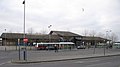 The front of the main Oxford railway station, northwest of Frideswide Square.
 -
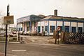 The Oxford Rewley Road railway station in 1994, north of the current Frideswide Square on the site of the Saïd Business School.
 -
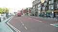 The south side of Frideswide Square looking east before the 2015 redevelopment.


References
- ^ Royal Oxford Hotel, Park End Street, Oxford, UK.
- ^ "Big clean-up at Oxford's Jam Factory is complete", Oxford Mail. 23 September 2020. Retrieved 16 January 2021.
- Hollybush Row, Oxford, UK
- ^ Frideswide Square, Cyclox: The Cycling Campaign for Oxford.
- ^ Andrew Malcolm, Are you going to Frideswide Square?, June 2009.
- ^ Frideswide Square — Stop R7, Oxfordshire, LiveBus.org.
- ^ Hamilton-Baillie Associates, Frideswide Square: Initial Analysis Option Appraisal, Oxford City Council, May 2006.
- ^ Frideswide Square, Oxford West End, UK.
- ^ Frideswide Square and Oxford Station, Oxfordshire County Council, February 2015
- ^ "Oxford's Frideswide Square redevelopment opens", BBC. 16 December 2015. Retrieved 16 January 2021.
External links
51°45′10″N 1°16′05″W / 51.7528°N 1.2680°W
This Oxfordshire location article is a stub. You can help Wikipedia by expanding it. |