
Frierfjord
| Frier Frierfjord | |
|---|---|
Skiensvassdraget | |
| Basin countries | Norway |
| Max. length | 14 kilometres (8.7 mi) |
| Max. width | 3 kilometres (1.9 mi) |
| Average depth | 93 metres (305 ft) |
| Settlements | Porsgrunn, Stathelle, Brevik, Herre |
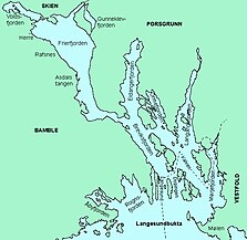
Frier or Frierfjord is a
Gunneklevfjord opens into the Porsgrunn/Skien River and is separated from Frierfjorden by the peninsula of Herøya.[1]
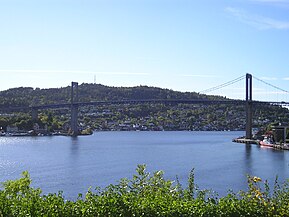
The Frierfjorden narrows to a width of about 300 metres (980 ft) at Breviksstrømmen, the mouth of the fjord, where the town of
cable stayed bridge
.
The fjord has a great deal of commercial ship traffic, including to Rafnes and Herre in Bamble, to Norsk Hydro in Porsgrunn, and formerly to Norske Skog Union in Skien.
Name
The fjord is named Frier (
Old Norse: Friðir). The name is derived from the word fríðr which means "beautiful" or "lovely". The official name of the fjord is Frier. Frierfjorden is also an approved name, but that one is "not prioritized".[1][2]
Media gallery
-
-
-

-
 Herøya, and the large industries


See also
References
- ^ Store norske leksikon (in Norwegian). Kunnskapsforlaget. Retrieved 19 September 2023.
- ^ "Frier (Norsk - Hovednavn)" (in Norwegian). Kartverket. Retrieved 19 September 2023.