
Glazier, Texas
Glazier, Texas | |
|---|---|
UTC-5 (CDT) | |
| GNIS feature ID | 2805788[1] |
Glazier is an
Every structure in Glazier except one house and the town's jail was destroyed by a
It is in the Canadian Independent School District.[8]
Climate
According to the
Köppen Climate Classification system, Glazier has a semi-arid climate, abbreviated "BSk" on climate maps.[9]
Gallery
-
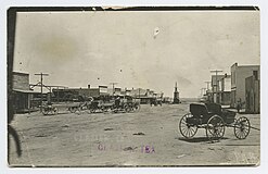 Glazier 1904–1918.
.jpg)
References
- ^ a b U.S. Geological Survey Geographic Names Information System: Glazier, Texas
- ^ Rand McNally. The Road Atlas '06. Chicago: Rand McNally, 2006, p. 98.
- ^ Zip Code Lookup
- ^ Zip Code Lookup
- ^ "The Panhandles' Only F5: Reconstructing the April 9, 1947 Higgins-Glazier Tornado". Archived from the original on September 11, 2015.
- ^ "Top Ten US Killer Tornadoes". Archived from the original on December 1, 2009. Retrieved May 30, 2010.
- ^ Associated Press, "Fear Casualty List to Grow; Towns Afire: Texas Village Razed", Chicago Daily Tribune, Chicago, Illinois, Thursday 10 April 1947, Volume CVI, Number 86, Section 1, Page 1.
- U.S. Census Bureau. Retrieved June 26, 2022. - Text list
- ^ Climate Summary for Glazier, Texas
Municipalities and communities of Hemphill County, Texas, United States | ||
|---|---|---|
| City |  | |
| CDP | ||
| Other community | ||
| ||
 | This article about a location in Hemphill County, Texas is a stub. You can help Wikipedia by expanding it. |