
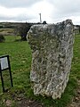
Glencullen Standing Stone
| Glencullen Standing Stone | |
|---|---|
| Native name Standing stone | |
| Location | Barrack Road, Glencullen, Dún Laoghaire–Rathdown, Ireland |
| Coordinates | 53°13′11″N 6°13′03″W / 53.219772°N 6.217379°W |
| Height | 1.83 m (6.0 ft) |
| Built | c. 18th century BC |
| Official name | Glencullen |
| Reference no. | 276 |
 Location of Glencullen Standing Stone in County Dublin | |
Glencullen Standing Stone is a
Location
Glencullen Standing Stone is located on Barrack Road, Glencullen.[6]
History
The stone (made of
Viking invaders used the stones in a game of "rings." It is also known as "Queen Mab
."
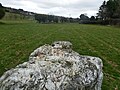
Gallery
-
 Facing west
 -
 Facing east
 -
 Facing west
 -
 Southwest face
 -
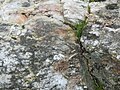 Detail
 -
 Southeast face
 -
 Northeast face
.jpg)
.jpg)
.jpg)


References
- ^ "Glencullen Standing Stone - Irish Photo Archive".
- ^ "Ireland In Ruins: Glencullen Standing Stone Co Dublin". 24 January 2014.
- ^ "Glencullen Standing Stone".
- ^ "Glencullen Standing Stone, Glencullen. co.Dublin - c.1700 b.c". 15 June 2012.
- ^ "megalithomania: Glencullen (Dublin) :: Standing Stone :: Visit notes".
- ^ "Standing stones".
