
Gräddö
This article has multiple issues. Please help improve it or discuss these issues on the talk page. (Learn how and when to remove these template messages)
|
Gräddö
Nabbo, Gräddö och Rävsnäs | |
|---|---|
| Nabbo, Gräddö and Rävsnäs | |
Stockholm county | |
| Municipality | Norrtälje Municipality |
| District | Rådmansö district |
| Area | |
| • Total | 5.84 km2 (2.25 sq mi) |
| Population | |
| • Total | 579 [1] |
| • Density | 99/km2 (260/sq mi) |
Gräddö is a locality in Rådmansö parish in Norrtälje Municipality in Roslagen.
History
Gräddö was first mentioned in documents in 1547.[2]
In 1739, the Swedish troops intended to be deployed in the War of the Hats embarked from here.[3]
In August 1809, the Swedish expeditionary force sailed from Gräddö to Ratan in Västerbotten to stop the Russian army from invading.[3]
At the end of the 19th century, Gräddö became a popular tourist destination and a number of towered summer houses were built in the area. Several guest houses were also started, Sjömans, Söderbergs, Strands, Skogshyddan, Ida Bergströms and Björkö örn. Gräddö also got a hot bath house, which, however, was moved to Gräddö-Asken in 1920. In 1933 Gräddö mission house was moved to its current location, after having previously been built in 1868 at Nabbo.[citation needed]
The shipyard at Gräddö was founded in 1924. The shipyard built exclusive motorboats until the 1960s.[3]
In 1959, Viking Line started ferry traffic from Gräddö to Mariehamn on Åland and on to Galtby, Korpo in Finland (Åboland archipelago). The following year, the traffic was moved to Kapellskär as the departure port in Sweden.[3]
In 2015, Statistics Sweden demarcated an urban area named by Statistics Sweden as Nabbo, Gräddö and Rävsnäs. The settlement also includes the nearby towns of Rävsnäs and Nabbo.[4]
Gallery
-
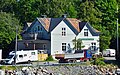 Thecommunity centerat Gräddö.
 -
 M/Y Salt designed by Knud H Reimers in 1938 and built at Gräddö shipyard.


References
- ^ Statistical agglomerations 2020, population, land area, population density per agglomeration. Statistics Sweden.
- ^ "Register:" (PDF).
- ^ ISBN 91-518-4003-0.
- ^ Changes in the number of urban areas 2010-2015. Statistics Sweden.