
Great Wakering
This article needs additional citations for verification. (April 2015) |
| Great Wakering | ||
|---|---|---|
Shire county | ||
| Region | ||
| Country | England | |
| Sovereign state | United Kingdom | |
| Post town | Southend-on-Sea | |
| Postcode district | SS3 | |
| Dialling code | 01702 | |
| Police | Essex | |
| Fire | Essex | |
| Ambulance | East of England | |
| UK Parliament | ||
Great Wakering is a village in the
History
According to a medieval tradition, Wakering (probably Great Wakering) was the site of a monastery during the seventh century AD. Two Christian cousins of King Ecgberht of Kent, named Æthelred and Æthelberht, were murdered at Eastry, a royal dwelling in the Kingdom of Kent, during King Ecgberht's reign (664–673). They were prevented by a miracle from being buried at Canterbury, and were taken instead to an existing monastery at Wakering in the Kingdom of Essex and enshrined there as saints. Ecgberht's brother and successor, King Hlothhere of Kent, is said by William of Malmesbury to have ridiculed the idea of their sanctity.
The village church, dedicated to St. Nicholas, dates back to
Great Wakering is a village steeped in history. It has many community links to the
Much of the land area around Great Wakering is closed to the public as it forms part of a
Sport and leisure
The local
Fairfax Saxons FC is a Great Wakering-based football club set up to raise awareness of men's health and to promote the community and local businesses via the medium of football. They play in the Southend Borough Combination Veterans League. This covers the Southend and surrounding areas. Home games are played at The Wakering Recreation Ground. It is a Sunday League set up. As a club, they train every Thursday and on Sunday when there is no game on. They are always welcoming new players and we hope to expand to create more teams within the club. They have two teams.
Notable people
- Leslie Stubbs - footballer for Southend United F.C. and Chelsea F.C.
- Peter Sampson - footballer for Bristol Rovers F.C.
- Alan McCormack - footballer for Brentford F.C.
- Sir Alan Orr – Lord Justice of Appeal
- Ryan Peniston - professional tennis player
Gallery
-
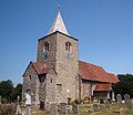 St. Nicholas' Church, Great Wakering
 -
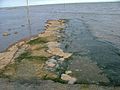 TheBroomway, a tidal path said to pre-date the Romans is a treacherous walk between Great Wakering and Foulness and was once the only route between the two places.
 -
 Marshland in front of the coast path behind Great Wakering New Ranges. This area is known locally as the Black Grounds. An old military lookout tower called 'X1' can be seen on the horizon.
 -
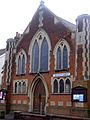 Methodist church on Great Wakering High Street.
 -
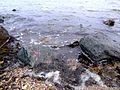 This beach is called the Wakering Stairs and belongs to the Ministry of Defence and can be accessed at their discretion. It is full of rocks and military debris.


References
- ^ "Parish population 2011". Retrieved 24 September 2015.
- ^ "Planning Statement" (PDF). Rochford District Council. Retrieved 24 March 2021.
- Rollason, D.W (1982). The Mildrith Legend. A Study in Early Medieval Hagiography in England. ISBN 0-7185-1201-4.
 Media related to Great Wakering at Wikimedia Commons
| International | |
|---|---|
| National | |