
Grist Mill Park
| Grist Mill Park | |
|---|---|
 | |
| Type | Urban park |
| Location | Yarmouth, Maine, U.S. |
| Coordinates | 43°47′56″N 70°10′41″W / 43.79885°N 70.17792°W |
| Area | 0.5 acres (0.0020 km2; 0.00078 sq mi) |
| Created | 1980s |
| Owned by | Town of Yarmouth |
| Open | Dawn to dusk daily |
Grist Mill Park is an
corn into flour using power generated by the water turbines set in the fast-flowing river below. Between 1870 and 1885, it was the site of Ansel Loring's second mill, named Yarmouth Flour Mill.[5]
The park is around 0.5 acres (0.20 ha).[6]
-
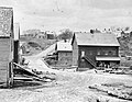 A 19th-century westerly view of one of the former grist mills (right) on the site of today's park

References
- ^ "Grist Mill Park". yarmouthcommservices. Retrieved May 18, 2024.
- ^ Royal River Corridor Study Y er Corridor Study Yarmouth, Maine Natur armouth, Maine Natural Resour al Resource Reconnaissance Surveys – University of Southern Maine (2008)
- ^ Royal River Corridor Master Plan – Yarmouth Town Council (2008)
- ^ The First Falls - Yarmouth's town website
- ^ Ancient North Yarmouth and Yarmouth, Maine 1636-1936: A History, William Hutchinson Rowe (1937)
- ^ Town of Yarmouth Open Space Plan 2019 – Royal River Conservation Trust