Gučevo
| Gučevo | |
|---|---|
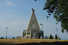
 Monument on Crni vrh | |
| Highest point | |
| Elevation | 779 m (2,556 ft)[1] |
| Coordinates | 44°28′50″N 19°11′04″E / 44.48056°N 19.18444°E |
| Geography | |
| Location | Western Serbia |
Gučevo (
mountain in western Serbia, near the town of Loznica, overlooking the Drina river and Banja Koviljača
. Its highest peak Crni vrh has an elevation of 779 meters above sea level.
The mountain was a site of
Battle of Gučevo between Serbian and Austro-Hungarian army in World War I. At the top of the mountain there is a monument to Serbian and Austro-Hungarian soldiers.[2]
References
- ^ Jovan Đokić. "Katalog planina Srbije". PSD Kopaonik Beograd. Archived from the original on 2011-05-18.
- ^ Gučevo, Banja Koviljača.org, archived from the original on 2010-08-08

