
Guhagar
Guhagar | |
|---|---|
town | |
UTC+5:30 (IST) | |
| PIN | 415703 |
| Telephone code | 02359 |
| Vehicle registration | MH-08 |
Guhagar (Marathi pronunciation:
Alphonso mangoes. The nearest city and railhead is Chiplun, about 44 kilometres (27 mi) away. The economy of Guhagar boomed after the Dabhol Power Company
, a few kilometres north was commissioned in the early 1990s. Hotels sprung up and residents were given well-paid jobs.
Guhagar is famous for
Shree Vyadeshwar temple.[1]
Guhagar's coconut is very famous in Konkan.
Geography
A word Guhagar means cave house in local language Guhagar is located at 17°28′N 73°12′E / 17.47°N 73.2°E.[2] It has an average elevation of 10 metres (33 feet). Guhagar has been featured in several films, the recent one being the Marathi Film Killa (film)
Demographics
As of 2001[update] India census,[3] Guhagar had a population of 3205. Males constitute 52% of the population and females 48%. Guhagar has an average literacy rate of 82%, higher than the national average of 59.5%: male literacy is 86%, and female literacy is 78%. In Guhagar, 10% of the population is under 6 years of age.
Gallery
-
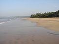 View of Guhagar Beach
 -
 Durga Devi Temple
 -
 Pindi of Shri Vyadeshwar
 -
 Shri Vyadeshwar Aarti
.jpg)


References
Wikimedia Commons has media related to Guhagar.
Wikivoyage has a travel guide for Guhagar.
- ^ "Guhagar". India: Puneri Travellers. 3 November 2014.
- ^ Falling Rain Genomics, Inc - Guhagar
- ^ "Census of India 2001: Data from the 2001 Census, including cities, villages and towns (Provisional)". Census Commission of India. Archived from the original on 16 June 2004. Retrieved 1 November 2008.
Ratnagiri district topics | ||
|---|---|---|
| Geography | .svg) | |
| Flora and fauna | ||
| Cities and towns | ||
| Transport | ||
| Lok Sabha constituencies | ||
| Vidhan Sabha constituencies | ||
Talukas | ||