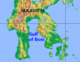
Gulf of Boni
Appearance
| Gulf of Boni/Bone | |
|---|---|
 Map of the Gulf of Boni | |
| Location | Sulawesi |
| Coordinates | 4°0′S 120°45′E / 4.000°S 120.750°E |
| Basin countries | Indonesia |
The Gulf of Boni
Extent
The International Hydrographic Organization (IHO) defines the Gulf of Boni (or Bone) as being one of the divisions of the East Indian Archipelago.[3] It is defined as the waters north of the "line from Tanjung Lassa, Celebes, to the North point of Kabaena Island (5°05′S 121°52′E / 5.083°S 121.867°E) and thence up this meridian to the coast of Celebes".[1]
See also
References
Citations
- ^ a b IHO (1953), §48 (k).
- ^ IHO (1953), §48 (g).
- ^ IHO (1953), §48.
Bibliography
- Limits of Oceans and Seas, 3rd ed. (PDF), International Hydrographic Organization, 1953, archived from the original (PDF) on 2018-10-05, retrieved 29 December 2020.

