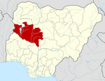
Gurara, Nigeria
Gurara | |
|---|---|
UTC+1 (WAT) | |
| 3-digit postal code prefix | 910 |
| ISO 3166 code | NG.NI.GU |
 | |
Gurara is a
. Its headquarters are in the town of Gawu. Major inhabitants are the Gwari people. The Gurara Waterfalls is found here.It has an area of 954 km2 and a population of 90,974 at the 2006 census.
The postal code of the area is 910.[1]
Climate
Gurara experiences
scorching all year. With grasses and occasionally bushes, it is primarily made of sand. Gurara experiences 68°F average yearly temperatures and 76′′ of annual precipitation. With an average humidity of 33% and a UV-index of 7, it is dry for 291 days out of the year.[2][3]
References
- ^ "Post Offices- with map of LGA". NIPOST. Archived from the original on 2012-11-26. Retrieved 2009-10-20.
- ^ "Gurara weather and climate ☀️ Best time to visit 🌡️ Temperature". www.besttravelmonths.com. Retrieved 2023-09-27.
- ^ "Gurara, Niger, Nigeria 10-Day Weather Forecast - The Weather Channel | Weather.com". The Weather Channel. Retrieved 2023-09-27.

