
Hübschhorn
| Hübschhorn | |
|---|---|
Alpine mountains above 3000 m | |
| Coordinates | 46°14′12.2″N 8°3′18.2″E / 46.236722°N 8.055056°E |
| Geography | |
 Hübschhorn Location in Switzerland | |
| Location | Valais, Switzerland |
| Parent range | Lepontine Alps |
The Hübschhorn is a mountain of the Lepontine Alps, overlooking the Simplon Pass in the canton of Valais. It belongs to the Monte Leone massif. Its altitude is 3190m/10'460 ft.
Access roads
The car access is both from Italian and Swiss sides by following the road towards the
Normal climbing route
To climb Hübschhorn you start walking from the road towards a small lake which is directly below the mountain (Rotelsee). From there continue up by following a hardly visible steep path. You will need around three hours from the road to the summit.
You will be able to see the complete route to Wasenhorn and the glacier route to Breithorn (Simplon), and enjoy the views of the Weissmies group in the south-west direction.
-
 Hübschhorn seen from Simplon Pass (2017)
 -
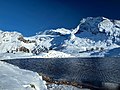 Hübschhorn with Hopschusee


References
External links
- Hübschhorn on Hikr
- Hübschhorn - Route description on Mountains for Everybody
This article about a mountain, mountain range, or peak located in Valais is a stub. You can help Wikipedia by expanding it. |