
Hallfield
| Hallfield | |
|---|---|
West Yorkshire | |
| Ambulance | Yorkshire |
| UK Parliament | |
Hallfield or Hallfields is an area predominantly of
History and development
The Hallfield area was for many years before residential development largely in the grounds of the Hallfield Mansions, a large house which lay derelict for many years until it was replaced in the 2000s by a medical centre. The area was from the 1930s to the 1950s home to the
Hallfield today

Today the estate has fallen into relative disrepair and as a rule, house prices are the cheapest in Wetherby, cheaper than other council estates, such as those around the Ainsty area of the town. Around half of the housing stock on the estates are now privately owned. In 2009 community notice boards were placed around the estate, these provide publicity to local issues and events. Recent problems with anti-social behaviour, particularly around the playing fields, local shops and the Freemans Way underpass have led to Leeds City Council and West Yorkshire Police engaging in a programme of community consultation and increasing police foot-patrols.
In June 2013 the Mason Fields playground was closed by councillors due to public health concerns after the site had been occupied by travellers. Parts of the amenity, as well as the adjacent cemetery, had been used as toilet facilities and the play equipment had been damaged.[1]
Amenities
Hallfield is situated close to Wetherby town centre, and backs onto the Horsefair Shopping Centre, providing easy access to local amenities. The area itself has a newsagent/ off-licence, a community centre, surgery, cemetery, playing fields, junior school, as well as being the location of
Housing styles
The majority of the housing on the estate is council housing, low rise and mostly 2-3 bedroomed semi-detached and terraced houses. The estate is notable for having many unusual chalet-style terraced houses. The majority of the houses were constructed in the 1950s, however there are some 1970s houses on Burrel Close, the Chase, Freemans Way and Saddlers Walk as well as some 2010s houses built on Hallfield Lane on the site of the former veterinary surgery.
-
 Chalet style terraced houses on First Avenue
 -
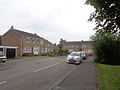
 More conventional double-fronted semi-detached houses on Fourth Avenue
 -
 Four-in-a-row terraced houses on Third Avenue
 -
 Bungalows on Hallfield Lane
 -
 Terraced houses built in a Radburn style arrangement on Saddlers' Walk
 -
 1970s private mews-style terraced houses on the Chase
_002.jpg)
_001.JPG)
.jpg)
.JPG)
.jpg)
_002.JPG)
References
- ^ "Clean up after travellers leave". 13 June 2013. Retrieved 14 March 2015.