
Harding Circle Historic District
reliable sources. (November 2013)
)Harding Circle Historic District | |
 | |
  | |
| Location | Sarasota, Florida |
|---|---|
| Coordinates | 27°19′8″N 82°34′37″W / 27.31889°N 82.57694°W |
| NRHP reference No. | 00001650[1] |
| Added to NRHP | January 16, 2001 |
The Harding Circle Historic District is a
.The district is on
St. Armand's Key, adjacent to Lido Key
, and is centered on Harding Circle, in the middle of the key, around which is the retail area of the key.
The circle was named after Warren G. Harding US president at the time the roads were laid out by Owen Burns and John Ringling for their "Ringling Isles" development during the early 1920s. The streets on the key were named to follow the same presidential naming convention with a large boulevard running north to south called the Avenue of the Presidents.
Most of the land is dredged fill provided by Burns to enlarge the natural barrier islands that separate the
Longboat Key
, another barrier island to the north also connected to Lido Key by a bridge).
Gallery
-
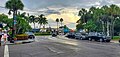 Harding Circle
 -
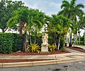 One of the many statues in the Harding Circle Historic District


References
External links
- Sarasota County listings at National Register of Historic Places
- Sarasota County listings at Florida's Office of Cultural and Historical Programs
- Visit St. Armands Circle
This article about a property in Sarasota County, Florida on the National Register of Historic Places is a stub. You can help Wikipedia by expanding it. |