
Hebel, Queensland
| Hebel Federal division(s) | Maranoa | ||||||||||||||
|---|---|---|---|---|---|---|---|---|---|---|---|---|---|---|---|
| |||||||||||||||
Hebel (pronounced he-bell) is a rural town and locality in the Shire of Balonne, Queensland, Australia.[2][3] It is on the border of Queensland and New South Wales.[4] In the 2016 census, Hebel had a population of 67 people.[1]
Geography
Hebel is in south-west Queensland situated 4 kilometres (2 mi) north of the border with New South Wales on the Castlereagh Highway. It is the eastern corner of the locality.[4]
The
In the west of the locality is the Culgoa River and the Culgoa Floodplain National Park (28°54′59″S 147°00′40″E / 28.9164°S 147.0111°E),[6] which extends into neighbouring Jobs Gate.[4][7]
There are a number of homesteads in the locality:[8]
- Balgi (28°50′33″S 147°47′37″E / 28.8425°S 147.7937°E)
- Ballandool (28°58′18″S 147°38′44″E / 28.9716°S 147.6455°E)
- Byra (28°58′43″S 147°13′03″E / 28.9785°S 147.2175°E)
- Currawillinghi (28°56′16″S 147°45′22″E / 28.9377°S 147.7560°E)
- Davirton (28°50′02″S 147°28′22″E / 28.8340°S 147.4729°E)
- Goonaroo (28°56′33″S 147°50′46″E / 28.9425°S 147.8462°E)
- Kinglebilla (28°49′00″S 147°28′40″E / 28.8166°S 147.4779°E)
- Koala (28°58′00″S 147°46′17″E / 28.9668°S 147.7713°E)
- Morley (28°53′00″S 147°36′48″E / 28.8832°S 147.6134°E)
- Tara (28°58′56″S 147°16′19″E / 28.9821°S 147.2720°E)
- Yattenbury (28°53′48″S 147°41′59″E / 28.8968°S 147.6996°E)
History

The town was reputedly named after a
Curriwillinghi Post Office opened on 1 January 1864 (named after the Curriwillinghi pastoral station, which still exists as at 2020 at 28°55′54″S 147°46′02″E / 28.9317°S 147.7672°E [4]).[12]
Circa 1886, Hebel was established as a border township with a border
In 1897 a dance hall was built. It is now the general store.[13]

Hebel Provisional School opened on 11 April 1901. On 1 January 1909, it became Hebel State School.[14][15]
The Hebel Post office closed in 1989.[12]
At the
In the 2016 census, Hebel had a population of 67 people.[1]
During 2020 and 2021, the Queensland border was closed due to the
Hebel was the feature of ABC Back Roads Series 8, Episode 11; it was aired on 25 July 2022.[20][21]
Facilities

Visitors to the village will find a general store, caravan park, hotel, and coffee shop.

Education
Hebel State School is a government primary (Preparatory to Year 6) school for boys and girls in Maud Street (28°58′15″S 147°47′28″E / 28.9709°S 147.7910°E).[24][25] In 2015, it had an enrolment of eleven students with two teachers (one full-time equivalent) and five non-teaching staff (two full-time equivalent).[26] In 2018, the school had an enrolment of seven students with one teacher and five non-teaching staff (2 full-time equivalent).[27]
There is no secondary school in Hebel. The nearest secondary school is Dirranbandi State School (to Year 10) and St George State High School (to Year 12).[4]
Transport
There are a number of airstrips in the locality:[28]
- Balgi airstrip (28°50′58″S 147°48′00″E / 28.8494°S 147.7999°E)
- Ballandool airstrip (28°57′53″S 147°38′42″E / 28.9646°S 147.6450°E)
- Brenda airstrip (28°49′48″S 147°24′58″E / 28.8300°S 147.4161°E)
- Byra airstrip (28°58′30″S 147°11′39″E / 28.9749°S 147.1941°E)
- Davirton airstrip (28°49′40″S 147°28′51″E / 28.8279°S 147.4808°E)
- Hebel airstrip (28°58′44″S 147°48′59″E / 28.9788°S 147.8165°E)
Amenities
Hebel Community Hall is at 40–50 William Street (28°58′23″S 147°47′43″E / 28.9730°S 147.7952°E).[29]
Bokhara River Campground is a 0.84-hectare (2.1-acre) site on James Street on the north side of town (28°58′10″S 147°47′48″E / 28.9694°S 147.7967°E).[29]
Hebel Racecourse is a 24-hectare (59-acre) reserve west of Henry Street (28°58′34″S 147°47′25″E / 28.9761°S 147.7903°E).[29]
Hebel Cemetery is on the south-east edge of the town (28°58′35″S 147°47′50″E / 28.9764°S 147.7971°E).[30]
Attractions
The front of the Hebel Hotel featured brightly-coloured art work by John Murray, which the interior furnishings are made of recycled items found in the bush.[13]
The Hebel Historical Circle is a walk around the town illustrates places of historic interest.[13]
The general store is also a cafe and restaurant; it retains its original dance floor.[13]
Gallery

-
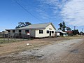
 General store, Castlereagh Highway (2021).
 -
 Community Hall, William Street (2021).
 -
 Local library (2021).
 -
 Hebel State School (2021).
 -
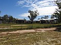 Hebel State School oval (2021).
 -
 Hebel Bicentennial Park, William Street (2021).
 -
 Hebel Historical Circle, in the Bicentennial Park (2021).
 -
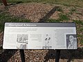 Historical Circle information panel example (2021).
 -
 Artwork made from barbwire, of a person pushing a wheelbarrow, with a dog (2021).
 -
 Hebel-Goodooga Road going south-west (2021).


References
- ^ a b c Australian Bureau of Statistics (27 June 2017). "Hebel (SSC)". 2016 Census QuickStats. Retrieved 20 October 2018.
- ^ "Hebel – town in Shire of Balonne (entry 15625)". Queensland Place Names. Queensland Government. Retrieved 9 May 2020.
- ^ "Hebel – locality in Shire of Balonne (entry 42681)". Queensland Place Names. Queensland Government. Retrieved 9 May 2020.
- ^ State of Queensland. Retrieved 3 December 2020.
- ^ "Bokhara River – river in the Balonne Shire (entry 3495)". Queensland Place Names. Queensland Government. Retrieved 10 May 2020.
- ^ "Culgoa Floodplain National Park – national park in Shire of Balonne (entry 39439)". Queensland Place Names. Queensland Government. Retrieved 11 May 2020.
- ^ "Culgoa Floodplain National Park - Nature, culture and history". Department of Environment and Science. Queensland Government. Archived from the original on 3 December 2020. Retrieved 10 May 2020.
- ^ "Homesteads - Queensland". Queensland Open Data. Queensland Government. 18 November 2020. Archived from the original on 24 November 2020. Retrieved 24 November 2020.
- CC-BY-4.0 licensed text from: "Yuwaalaraay". Queensland Aboriginal and Torres Strait Islander languages map. State Library of Queensland. Retrieved 23 January 2020.
- CC-BY-4.0 licensed text from: "Yuwaalayaay". Queensland Aboriginal and Torres Strait Islander languages map. State Library of Queensland. Retrieved 23 January 2020.
- ^ Balonne (Qld.). Council (1996), Window of the west : The Balonne Shire, Balonne Shire Council, archived from the original on 3 December 2020, retrieved 10 May 2020
- ^ a b c Premier Postal History. "Post Office List". Premier Postal Auctions. Archived from the original on 15 May 2014. Retrieved 10 May 2014.
- ^ a b c d "Hebel". Southern Queensland Country Tourism. 2020. Archived from the original on 10 May 2020. Retrieved 10 May 2020.
- ISBN 978-1-921171-26-0
- ^ "Opening and closing dates of Queensland Schools". Queensland Government. Retrieved 18 April 2019.
- ^ Australian Bureau of Statistics (25 October 2007). "Hebel (Balonne Shire) (State Suburb)". 2006 Census QuickStats. Retrieved 4 May 2008.
- ^ "Road Status Update for South West". Department of Transport and Main Roads. 19 December 2021. Archived from the original on 18 December 2021. Retrieved 19 December 2021.
{{cite web}}: CS1 maint: unfit URL (link) - )
- ^ "This mound is all the border protection this town's got and it was hardly dirt cheap". ABC News. 8 August 2021. Archived from the original on 31 December 2021. Retrieved 24 January 2022.
- ^ Perry, Kevin (24 July 2022). "HEATHER EWART travels to the tiny Queensland town of HEBEL - This week on BACK ROADS". TV Blackbox. Retrieved 25 July 2022.
- ^ "Pub aficionado Heather Ewart's favourite back roads watering holes". ABC News. 24 July 2022. Retrieved 25 July 2022.
- ^ "Library location and hours". Balonne Shire Council. Archived from the original on 23 October 2017. Retrieved 8 May 2017.
- ^ "Hebel Library". Public Libraries Connect. State Library of Queensland. Archived from the original on 2 February 2017. Retrieved 29 January 2017.
- ^ "State and non-state school details". Queensland Government. 9 July 2018. Archived from the original on 21 November 2018. Retrieved 21 November 2018.
- ^ "Hebel State School". Archived from the original on 26 March 2020. Retrieved 21 November 2018.
- ^ "2015 School Annual Report (Amended)" (PDF). Hebel State School. Archived (PDF) from the original on 2 February 2017. Retrieved 29 January 2017.
- ^ "ACARA School Profile 2018". Australian Curriculum, Assessment and Reporting Authority. Archived from the original on 27 August 2020. Retrieved 28 January 2020.
- ^ "Heliports and landing grounds - Queensland". Queensland Open Data. Queensland Government. 22 October 2020. Archived from the original on 16 November 2020. Retrieved 3 November 2020.
- ^ a b c "Land for public recreation - Queensland". Queensland Open Data. Queensland Government. 20 November 2020. Archived from the original on 22 November 2020. Retrieved 22 November 2020.
- ^ "Cemetery Areas - Queensland". Queensland Open Data. Queensland Government. 12 November 2020. Archived from the original on 15 November 2020. Retrieved 12 November 2020.
Further reading
- Whitcomb, Mike (1989), Hebel hallmarks : a local history, The Author