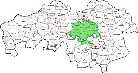
Het Groene Woud

Het Groene Woud (The Green Forest) is a special area of the Netherlands which is located in North Brabant between the cities of Tilburg, Eindhoven and 's-Hertogenbosch.[1] It includes nature reserves such as the Kampina, the Oisterwijk forests and fens, Velderbos and the Dommel.
In 2004 "Het Groene Woud" is designated by the government as a National Landscape. This is to prevent the area between the three large cities from becoming more urbanized.
The combination of nature, sustainable agriculture and environmental recreation form a valuable cultural and historical landscape. "Het Groene Woud" covers a total of 7,500 hectares of marshes, meadows and agricultural landscape. It covers the municipalities Boxtel, Sint-Oedenrode, Schijndel, Sint-Michielsgestel, Best, Oirschot, Oisterwijk, Haaren and Vught.
In Het Groene Woud, many species of
These include:

Hiking, canoeing and cycling activities are possible in this area.
References
- ^ "Gemeente Sint-Oedenrode / Info / Bezoekers / Natuur / Het Groene Woud". Archived from the original on 2013-11-03. Retrieved 2013-11-02.
- ^ "Edelherten in Het Groene Woud". Brabants Landschap. Retrieved 23 March 2020.
