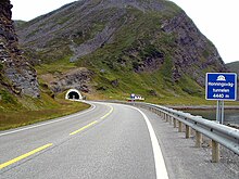
Honningsvåg Tunnel
 View of the tunnel | |
| Overview | |
|---|---|
| Location | Finnmark, Norway |
| Coordinates | 70°59′06″N 25°52′11″E / 70.9851°N 25.8697°E |
| Status | In use |
| Route | |
| Start | 70°58′40″N 25°50′30″E / 70.97778°N 25.84167°E |
| End | 70°59′20″N 25°55′00″E / 70.98889°N 25.91667°E |
| Operation | |
| Opened | 15 June 1999 |
| Operator | Statens vegvesen |
| Technical | |
| Length | 4,443 metres (14,577 ft) |
| No. of lanes | 2 |
| Width | 9 metres (30 ft) |
The Honningsvåg Tunnel (
Nordkapp Municipality in Finnmark county, Norway. It is located slightly north of the undersea North Cape Tunnel, and it is part of the European route E69 highway.[1]
The 4,443-metre (14,577 ft) long tunnel opened in 1999, at the same time as the
northernmost public road tunnel in the world.[2]
References
- Store norske leksikon. "Honningsvågtunnelen"(in Norwegian). Retrieved 2013-02-13.
- ^ Merzagora, Eugenio A.; Lotsberg, Gunnar (eds.). "Road Tunnels in Norway > 3 000 m". Road Tunnels in Norway. Retrieved 2013-02-13.
