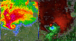
Hook echo
A hook echo is a pendant or hook-shaped
History

Because of the unpredictable and potentially catastrophic nature of tornadoes, the possibility of detecting tornadoes via radar was discussed in the meteorological community in the earliest days of meteorological radar.[5] The first association between tornadoes and the hook echo was discovered by E.M. Brooks in 1949.[6] Brooks noted circulations with radii of approximately 8–16 km on radar. These circulations were associated with supercell thunderstorms and were dubbed “tornado cyclones” by Brooks.
The first documented association between a hook echo and a confirmed tornado occurred near
Prominent
J.R. Fulks developed the first hypothesis on the formation of hook echoes in 1962.[9] Fulks analyzed wind velocity data from Doppler weather radar units which were installed in Central Oklahoma in 1960. Doppler data on wind velocity during thunderstorms demonstrated an association between strong horizontal wind shear and mesocyclones, which were identified as having the potential to produce tornadoes.[2]
Interpretation

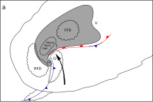
Hook echoes are a reflection of the movement of air inside and around a supercell thunderstorm. Ahead of the base of the storm, the inflow from the environment is sucked in by the instability of the air mass. As it moves upward, it cools slower than the cloud environment, because it mixes very little with it, creating an echo free tube which ends at higher levels to form a bounded weak echo region or BWER.[2] At the same time, a mid-level flow of cool and drier air enters the thunderstorm cloud. Because it is drier than the environment, it is less dense and sinks down behind the cloud and forms the rear flank downdraft, drying the mid-level portion of the back of the cloud. The two currents form a vertical windshear, which then develops rotation and can further interact to form a mesocyclone. Tightening of the rotation near the surface may create a tornado.[2]
Near the interaction zone at the surface, there will be a dry slot caused by the updraft on one side and the cloudy area below the rear flank downdraft on the other side. This is the source of the hook echo seen on radar near the surface. Hook echoes are thus a relatively reliable indicator of tornadic activity; however, they merely indicate the presence of a larger mesocyclone structure in the tornadic storm rather than directly detecting a tornado.
The use of Doppler weather radar systems, such as
Observational limitation
Hook echoes are not always obvious. Particularly in the Southern United States, thunderstorms tend to take on a structure of more precipitation surrounding a mesocyclone, which leads to the high precipitation (HP) variation supercell that obscures the hook shape. HP supercells instead often have a high reflectivity pendant or front flank notch (FFN), appearing like a "kidney bean" shape. Another limiting factor is radar resolution. Prior to 2008, NEXRAD had a range resolution of 1,000 meters, while the processes which lead to a hook echo happen on a smaller scale.[11]
See also
References
- ISBN 978-1-878220-34-9.
- ^ S2CID 54785955.
- ^ Angel, Jim (Apr 9, 2013). "ISWS is Pioneer in Tracking Tornadoes by Radar". Illinois State Water Survey. Archived from the original on 2013-06-01. Retrieved 2013-05-22.
- ^ "Tornado Warning Guidance" (PDF). National Weather Service. Spring 2002. Archived from the original (PDF) on March 6, 2013. Retrieved June 16, 2013.
- ^ a b Huff, F.A., H.W. Hiser, and S.G. Bigler, 1954: Study of an Illinois tornado using radar, synoptic weather and field survey data. Report of Investigation 22, Champaign, IL, pp. 73
- .
- ^ Angel, Jim (Apr 9, 2013). "60th Anniversary of the First Tornado Detected by Radar". Illinois State Climatology. Illinois State Water Survey. Retrieved May 22, 2013.
- .
- ^ Fulks, J. R. (1962). On the Mechanics of the Tornado. U. S. Weather Bureau.
{{cite book}}:|work=ignored (help) - ^ Paul Schlatter, Warning Decision Training Branch (September 2009). "WSR-88D Distance Learning Operations Course; Topic 5, Lesson 19". Archived from the original on February 27, 2013. Retrieved June 16, 2013.
- ^ "NWS Louisville: Supercell Structure and Dynamics". Retrieved 1 June 2013.
Further reading
- Fujita, Tetsuya (1965-02-01). "Formation and Steering Mechanisms of Tornado Cyclones and Associated Hook Echoes". Monthly Weather Review. 93 (2): 67–78. ISSN 1520-0493.
- Fujita, Tetsuya (1958-06-01). "Mesoanalysis of the Illinois Tornadoes of 9 April 1953". Journal of the Atmospheric Sciences. 15 (3): 288–296. ISSN 1520-0469.
- Wade, Patrick (2013-04-07). "Tornadoes' 'hook echo' discovered here 60 years ago". The News-Gazette. Champaign. Retrieved 2023-07-03.
- Burgess, Donald W.; Magsig, Michael A.; Wurman, Joshua; Dowell, David C.; Richardson, Yvette (2002-06-01). "Radar Observations of the 3 May 1999 Oklahoma City Tornado". Weather and Forecasting. 17 (3): 456–471. ISSN 1520-0434.
