
Howard Avenue Historic District
Howard Avenue Historic District | |
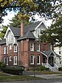
 Howard Avenue Methodist Church, now New Light Holy Church (1875-1890), 198 Howard Ave., Luzerne I. Thomas, architect. | |
  | |
| Location | Properties along Howard Ave. between I-95 and Washington Ave., New Haven, Connecticut |
|---|---|
| Coordinates | 41°17′31.7″N 72°55′57.4″W / 41.292139°N 72.932611°W |
| Area | 32 acres (13 ha) |
| Built | 1880 |
| Architect | Multiple |
| Architectural style | Colonial Revival, Late Victorian, Queen Anne |
| NRHP reference No. | 85002308[1] |
| Added to NRHP | September 12, 1985 |
The Howard Avenue Historic District is a 32-acre (13 ha)
Description and history
According to city maps and records, Howard Avenue was probably laid out in the 1640s. It was largely surrounded by farmland, and in the early 19th century it was given its present wide boulevard appearance, as part of an attempt by developer James Hillhouse to spur residential development. His attempt failed, and it was not until the 1860s, when a horsecar railway was run along the northern section, that serious development began. This development was further spurred by the creation of a large railyard just to its east by the
When listed in 1985, the district included 151 buildings deemed to contribute to the historic character of the area. It includes properties fronting Howard Avenue from Minor Street (just south of Washington Avenue) to Fifth Street (just north of
Gallery
-
 Nicholas Countryman House, 622 Howard Ave. (1866), Rufus G. Russell, with early influence ofGothic Stick style.
 -
 Episcopal Church of the Ascension (1887), 33 Lamberton St.,Leoni Robinson.
 -
 164 Howard Ave. (1885).
 -
 142 Howard Ave. (about 1900).


See also
References
- ^ a b "National Register Information System". National Register of Historic Places. National Park Service. March 13, 2009.
- ^ a b J. Paul Loether; Dorothea Penar; John Herzan (March 5, 1985). "National Register of Historic Places Inventory-Nomination: Howard Avenue Historic District". National Park Service. and Accompanying 27 photos, many from 1984
| Topics | |
|---|---|
| Lists by state |
|
| Lists by insular areas | |
| Lists by associated state | |
| Other areas | |
| Related | |