Idstedt
You can help expand this article with text translated from the corresponding article in Danish. (June 2023) Click [show] for important translation instructions.
|
Idstedt Isted | |
|---|---|
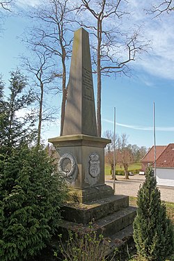
 Memorial to the Battle of Isted in Istedt | |
Location of Idstedt Isted within Schleswig-Flensburg district Schleswig-Flensburg | |
| Municipal assoc. | Südangeln |
| Government | |
| • Mayor | Edgar Petersen |
| Area | |
| • Total | 13.35 km2 (5.15 sq mi) |
| Elevation | 26 m (85 ft) |
| Population (2022-12-31)[1] | |
| • Total | 876 |
| • Density | 66/km2 (170/sq mi) |
| Time zone | UTC+01:00 (CET) |
| • Summer (DST) | UTC+02:00 (CEST) |
| Postal codes | 24879 |
| Dialling codes | 04625 |
| Vehicle registration | SL |
| Website | www.amt- suedangeln.de |
Idstedt (Schleswig and east of the Bundesautobahn 7.
On 24–25 July 1850, the
First War of Schleswig
.
References
- Statistisches Amt für Hamburg und Schleswig-Holstein.

