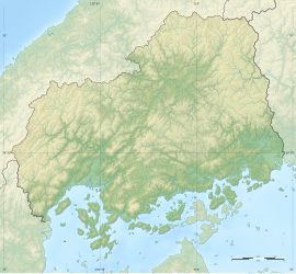
Jōrakuji-Nanatsuzuka Kofun Cluster
浄楽寺・七ツ塚古墳群 | |
 | |
| Location | Miyoshi, Hiroshima, Japan |
|---|---|
| Region | San'yō region |
| Coordinates | 34°33′13″N 133°18′44″E / 34.55361°N 133.31222°E |
| Altitude | 10 m (33 ft) |
| Type | kofun cluster |
| History | |
| Founded | 5th-6th century AD |
| Periods | Kofun period |
| Site notes | |
| Public access | Yes |
 | |
The Jōrakuji-Nanatsuzuka Kofun Cluster (浄楽寺・七ツ塚古墳群, Jōrakuji-Nanatsuzuka kofun-gun) is a group of
National Historic Site in 1972.[1]
Overview
The Miyoshi Basin in the
square-type (hōfun (方墳)). Mound No.12. the largest in this cluster, is a circular burial mound measuring 6 meters in height and 55 meters in diameter.[2]
In the Nanatsuzuka Burial Mounds, located approximately 116 meters south, consists of a total of 60 burial mounds, including one zenpō-kōen-fun (前方後円墳), which is shaped like a keyhole, having one square end and one circular end, when viewed from above. It has a total length of 29.5 meters. There are also 2
square-type hōfun. [2]
Based on the style of the
burial chambers and excavated artifacts, it is believed that these burial mounds were constructed in the middle to late Kofun period (5th to 6th centuries AD). The area around the burial mounds has been preserved and maintained as the Hiroshima Prefectural Miyoshi Fudoki no Oka Park (広島県立みよし風土記の丘), which houses the Prefectural Museum of History and Folklore. The site is a 15-minute walk from Kamisugi Station on the JR West Geibi Line.[2]
See also
References
- ^ "浄楽寺・七ツ塚古墳群". Cultural Heritage Online (in Japanese). Agency for Cultural Affairs. Retrieved 25 May 2022.
- ^ ISBN 4311750404.(in Japanese)
External links
![]() Media related to Hiroshima prefectural Miyoshi Fudoki No Oka Park at Wikimedia Commons
Media related to Hiroshima prefectural Miyoshi Fudoki No Oka Park at Wikimedia Commons
- Hiroshima Prefectural Board of Education (in Japanese)


