
Jebel Shams
| Jabal Shams | |
|---|---|
Arabic) | |
| English translation | Mountain of Sun |
| Geography | |
 Jabal Shams Location in Oman  Jabal Shams Jabal Shams (Middle East)  Jabal Shams Jabal Shams (Asia) | |
| Location | |
| Parent range | Al-Hajar Mountains |
| Climbing | |
| Easiest route | (to South Summit) W4 route published by Ministry or Tourism, Oman (Grade 2 / 3)[2] |
Jabal Shams or Jebel Shams (
Arabia. Nearby is Jabal Akhdar
, another prominent peak in the region.
Description
The highest point of the mountain is the North Summit, which is occupied by a military base and is a restricted area. The Ministry of Tourism, Sultanate of Oman, states the North Summit to be 3,009 m (9,872 ft) high.[3]
The mountain also has a second summit, the South Summit, which is publicly accessible for trekking via the W4 Trail,[4] marked by the Oman Ministry of Tourism.[2] The elevation of the second south summit is 2,997 m (9,833 ft).[4]
-
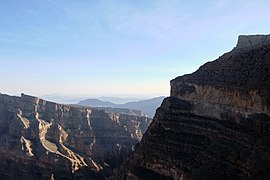
 A view from the top
 -
 Jebel Shams Balcony Walkway
 -
 View from the Balcony Walkway
 -
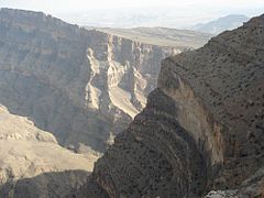
 The 'Grand Canyon' of the Middle East


See also
References
- ^ "Jabal ash Sham, Oman". Peakbagger.com. This prominence value is based on an elevation of 3,018 m.
- ^ a b Trekking Route 3
- ^ a b "Mountains in Oman". Ministry of Tourism, Sultanate of Oman. Archived from the original on 2011-07-15. Retrieved 2014-01-08.
- ^ a b "Trekking". website. Ministry of Tourism, Sultanate of Oman. Archived from the original on 2021-12-09. Retrieved 2014-01-08.
External links
- Travel Blog on Jebel Shams
- http://www.enhg.org/field/jshams04/jshams04.htm Archived 2016-03-03 at the Wayback Machine
- Flickr Images
- https://web.archive.org/web/20081005065647/http://www.geocities.com/evertinoman/shams.htm
Wikimedia Commons has media related to Jebel Shams.