
Jenesano
Jenesano
Piranguata, Genazzano | |
|---|---|
Municipality and town | |
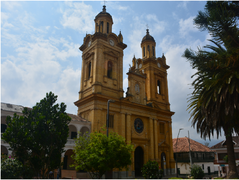
 View of Jenesano | |
|
UTC-5 (Colombia Standard Time) | |
| Website | Official website |
Jenesano is a town and municipality in the
Nuevo Colón in the west, Ramiriquí in the east, Boyacá, Boyacá in the north and Tibaná in the south.[1]
Etymology
Jenesano was called Piranguata at time of foundation. The name was changed in 1833 to Genazzano, referring to the province in Italy. Later, it became Jenesano, meaning "healthy people" or "healthy village".[1]
History
The area of Jenesano before the
zaque of Hunza
.
Modern Jenesano was not founded until 1828, after the independence of Colombia from the Spanish Empire.[1]
Economy
Main activity of Jenesano is
Gallery
-
 Church of Jenesano

References
Wikimedia Commons has media related to Jenesano.
- ^ a b c d (in Spanish) Official website Jenesano[permanent dead link]