
Königsberg Stock Exchange
This article includes a list of general references, but it lacks sufficient corresponding inline citations. (December 2012) |

The Königsberg Stock Exchange (
cultural centre
.
The first stock exchange in Königsberg was documented in 1619. Four years later, it was located in a new building of Kneiphof on the northern shore of the Alter Pregel; until 1798, it was accessible from the bridge Grüne Brücke. In 1699, Altstadt built its own stock exchange along the Hundegatt branch of the Pregel River. Kneiphof's building was rebuilt in 1798 as its second exchange, but it burned down in 1800. Kneiphof's third exchange was then partially constructed within the river in 1801. It was closed in 1875 because it was too small for the growing city.
Kneiphof's fourth and final stock exchange opened in 1875 in
German Army's postal service during World War I
, exhibitions were held instead at the stock exchange.
The stock exchange was heavily damaged by the 1944
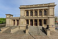
neo-classical architecture
.
-
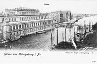 Königsberg Stock Exchange and the Pregel River
 -
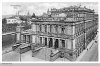 Königsberg Stock Exchange
 -
 Former interior of the stock exchange
 -
 Lion statues before the building
 -
 Main portal
 -
 Facade to the river
 -
 Panoramic view of the stock exchange building, Pregel River (center), Kneiphof island (left) and Estakadnyi Bridge (right) in Summer 2014


.jpg)
References
Wikimedia Commons has media related to Königsberg Stock Exchange.
- Albinus, Robert (1985). Lexikon der Stadt Königsberg Pr. und Umgebung (in German). Leer: Verlag Gerhard Rautenberg. p. 371. ISBN 3-7921-0320-6.
- Köster, Baldur (2000). Königsberg: Architektur aus deutscher Zeit (in German). Husum: Husum Druck- und Verlagsgesellschaft. p. 256. ISBN 3-88042-923-5.