
Kaien Island
mountain ridge, surrounded by coastal lowlands, the dominant central peak is Mount Hays reaching 708 metres (2,323 ft),[3] with a secondary peak, Mount Olfield reaching 555 metres (1,821 ft)[4]
to the northeast.
Located within the
invertebrates and intertidal fish.[6]
Kaien Island is central to the traditional territories of the Tsimshian First Nations, and has been permanently settled for more than 5,000 years.[6] The city of Prince Rupert, British Columbia is situated on the island. Casey Point is located on the western extremity of the island,[7] facing Digby Island, was the site of one of the coastal defence installations to protect the BC Coast during World War II. Another such installation was at Seal Cove on the island's northern tip.[8]
See also
- Prince Rupert Harbour
References
- ^ "Kaien Island". BC Geographical Names.
- ^ a b "Bulk Liquids Terminal, South Kaien Island, Prince Rupert, BC, Volume II Environmental Report" (PDF). Ocean Ecology.
- ^ "Mount Hays". BC Geographical Names.
- ^ "Mount Olfield". BC Geographical Names.
- ^ "Landforms of British Columbia, a Physiographic Outline" (PDF). University of Victoria.
- ^ a b "Coast Tsimshian pre-contact Economics and Trade: An Archaeological and Ethno-historic reconstruction" (PDF). University of British Columbia.
- ^ "Casey Point". BC Geographical Names.
- ^ "Seal Cove". BC Geographical Names.
Images
Wikimedia Commons has media related to Kaien Island.
-
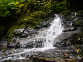 Stream cascades overmetasedimentary amphibolitebedrock
 -
 Dogwood Bunchberries in a bog
 -
 Coastal Rainforest in late summer


54°16′58″N 130°18′12″W / 54.28274°N 130.30341°W
This article about a location on the North Coast of British Columbia, Canada is a stub. You can help Wikipedia by expanding it. |