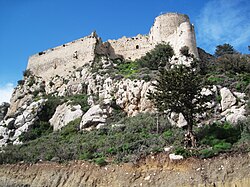
Kantara Castle
| Kantara Castle | |
|---|---|
 Kantara Castle | |
| General information | |
| Architectural style | Medieval |
| Country | de jure de facto |
| Coordinates | 35°24′23″N 33°55′24″E / 35.4064°N 33.9233°E |
Kantara Castle (
History
Kantara is situated to the east of the
Serving as a watchtower for pirate raids, an administrative centre and a place of incarceration the castle saw next to no fighting. In 1191, it was taken by
Recognizing the importance of the three Kyrenian castles James I of Cyprus and Peter II of Cyprus vastly expanded their fortifications. During their reign Kantara was transformed into a garrison castle, barracks and an enormous cistern were erected. Another cistern located at the basement of the castle was converted into a prison and later made into rooms for the captain of garrison. In 1489, the Republic of Venice acquired the island, 1519 Italian engineers branded the castle as obsolete. At which time the Kyrenian mountain castles fell into disuse, the last garrison departing in 1525. The castle was finally dismantled in 1560. Kantara's buildings remain in a relatively good condition until they were subjected to looting in the early 20th century. In 1905, the castle was classified as historic heritage due to the efforts of the French archaeologist Camille Enlart. In 1914, British colonial authorities under George Jeffery undertook restoration work at the castle, in an effort to attract sightseers. In 1939, the foundation of the horseshoe tower was refurbished in order to prevent it from collapsing.[5][6]
Architecture


Kantara is situated on an elevation of 550–600 metres (1,800–1,970 ft)
The steep crags limit the available pathways to a narrow valley on its eastern side, which is guarded by twin towers named Nicolas and Faucherre respectively. The first gate is followed by a barrel vaulted
The surrounding 120 by 70 metres (390 ft × 230 ft) wall contained ten garrison rooms which were constructed in the late 14th century, the barracks were connected with a latrine. A concealed postern, guarded by two towers lies on the south–western corner of the castle. To the south of the main gate, was built a rectangular, barrel vaulted keep, used a prison, later converted into a cistern. The centre of its northern wall is graced by a refined late 14th century Frankish window built from what once was an embrasure. The shape of the embrasures throughout the castle points out that they were mainly used by crossbowmen. At the top of the castle stand the ruins of "The Queen's Chamber", an alleged fortified chapel destroyed in a Turkish naval bombardment in 1525 and looted in the 19th century.[9][10]
References
- ^ Petre 2010, pp. 120–123, 126.
- ^ Morelle 2014, pp. 293–295.
- ^ Ucar 2004, pp. 87–91.
- ^ Molin 1995, pp. 18–28.
- ^ a b Morelle 2014, pp. 298–300.
- ^ a b c Ucar 2004, pp. 89–91.
- ^ Morelle 2014, pp. 300–304.
- ^ Morelle 2014, pp. 304–308.
- ^ Morelle 2014, pp. 308–314.
- ^ Ucar 2004, pp. 92–94.
Bibliography
- Molin, Bengt Kristian (1995). The Role of Castles in the Political and Military History of Crusader States and the Levant 1187 to 1380. etheses.whiterose.ac.uk (PhD thesis). Leeds: University of Leeds. pp. 1–448.
- Morelle, Nicolas (2014). "The Castle of Kantara - A Key to the Evolution of Active Defense in the 13th Century Between the Eastern and the Western Worlds". The Castle Studies Group Journal. Exeter: Castle Studies Group: 292–318. ISSN 1741-8828. Retrieved 8 May 2017.
- Petre, James (2010). Crusader Castles of Cyprus: The Fortifications of Cyprus under the Lusignans 1191–1489 (PDF) (PhD). Cardiff: University of Cardiff. pp. 1–413. OCLC 870568051. Retrieved 8 May 2017.
- Ucar, Gulnur (2004). The Crusader Castles of Cyprus and Their Place within Crusader History (PDF). Middle East Technical University (PhD). Ankara. pp. 1–178. OCLC 58466417. Retrieved 8 May 2017.

