
Kenyon Bridge
Kenyon Bridge | |
Cornish City, New Hampshire | |
| Coordinates | 43°27′47″N 72°21′12″W / 43.46306°N 72.35333°W |
|---|---|
| Area | 0.5 acres (0.20 ha) |
| Built | 1882 |
| Architect | Tasker, James |
| Architectural style | Multiple Kingpost Truss |
| NRHP reference No. | 78000223[1] |
| Added to NRHP | May 22, 1978 |
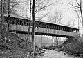
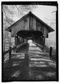
The Kenyon Bridge, also known as the Blacksmith Shop Bridge, is a historic covered bridge spanning Mill Brook near Town House Road in Cornish, New Hampshire, United States. Built in 1882, it is one of New Hampshire's few surviving 19th-century covered bridges. It was listed on the National Register of Historic Places in 1978.[1]
Description and history
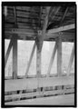
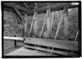
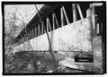
The Kenyon Bridge is located in a wooded rural setting, a short way east of Town House Road about 0.3 miles (0.48 km) south of its junction with Center Road. It spans Mill Brook in a roughly east-west orientation. It is 96 feet (29 m) long and 14.5 feet (4.4 m) wide, with a roadbed 90 feet (27 m) long and 13 feet (4.0 m) wide. The bridge rests on dry-laid stone abutments. The bridge's multiple
The bridge was built in 1882 by James Frederick Tasker (1826–1903), a local builder well known for his bridges. Its historic name, Blacksmith Shop Bridge, derives from a shop nearby owned by blacksmith John Fellows.[2] It underwent a major rehabilitation in 1963. It is now closed to vehicular traffic, but open to pedestrians.
Images
- Structural design of the Kenyon Bridge
-
 (image 1 of 14)
2003
Detail: eastern abutment, east-northeast 60° (HAER) -
 (image 2 of 14)
2003
Detail: midspan, south panel (HAER) -
 (image 3 of 14)
2003
Framing detail: north panel (HAER) -
 (image 4 of 14)
2003
Downstream elevation, looking north (HAER) -
 (image 5 of 14)
2003
End post detail: west end (HAER) -
 (image 6 of 14)
2003
Interior view from the west (HAER) -
 (image 7 of 14)
2003
Interior view, east portal, looking east (HAER) -
 (image 8 of 14)
2003
Interior view, looking west (HAER) -
 (image 9 of 14)
2003
(HAER) -
 (image 10 of 14)
2003
Perspective showing roadway from the west, looking east (HAER) -
 (image 11 of 14)
2003
Perspective, northwest by 295° (HAER) -
 (image 12 of 14)
2003
Portal, east elevation (HAER) -
 (image 13 of 14)
2003
Portal, west elevation, bearing due east (HAER) -
 (image 14 of 14)
2003
Upstream elevation, bearing southwest 215° (HAER)


.jpg)


See also
Other covered bridges in Cornish
- Blow-Me-Down Covered Bridge
- Cornish-Windsor Covered Bridge
- Dingleton Hill Covered Bridge
Covered bridges in nearby West Windsor, Vermont
Other bridges elsewhere
- List of bridges documented by the Historic American Engineering Record in New Hampshire
- List of bridges on the National Register of Historic Places in New Hampshire
- List of bridges on the National Register of Historic Places in Vermont
- List of covered bridges in Vermont
- List of crossings of the Connecticut River
- List of New Hampshire covered bridges
- National Register of Historic Places listings in Sullivan County, New Hampshire
References
- ^ a b "National Register Information System". National Register of Historic Places. National Park Service. July 9, 2010.
- ^ a b "NRHP nomination for Kenyon Bridge". National Park Service. Retrieved 2014-07-05.
External links
- New Hampshire DHR page on the bridge (dated info)
- Historic American Engineering Record (HAER) No. NH-40, "Kenyon Bridge, Spanning Mill Brook, Town House Road, Cornish City, Sullivan County, NH", 13 photos, 7 data pages, 1 photo caption page
