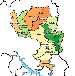
Kpandai District
Kpandai District
Nawuri | |
|---|---|
UTC+0 (GMT) | |
| ISO 3166 code | GH-NP-KP |
Kpandai District
Geography
The district shares boundaries with East Gonja to the west, Nanumba South to the north, Nkwanta North and Nkwanta South to the East and Krachi West to the south.
Population
The district is largely rural, with approximately 90% of the population engaged in local agriculture.[4] As of the 2010 census, the district population was 108,816 and included at least 24 different ethnic groups.[4] The district has a total population of 108,816, which is made up of 54,997 (50.54 percent) males and 53,819 (49.46 percent) females. The district has an urban population of 10,824 representing 9.9 percent and rural population 97,992 representing 90.1 percent.
Sources
References
- ^ "One District One Factory (1D1F)". www.moti.gov.gh. Archived from the original on 2021-04-11. Retrieved 2021-04-11.
- ^ "Northern » Kpandai". Archived from the original on 2013-03-05. Retrieved 2013-06-18.
- ^ "Ghana Northern Region". www.modernghana.com. Retrieved 2021-04-11.
- ^ a b Ghana Statistical Service (2014). "2010 Population & Housing Census: Kpandai District Analytical Report" (PDF). Archived from the original (PDF) on 2016-03-05. Retrieved 2018-10-13.

