
Kvaløya (Tromsø)
| Demographics | |
|---|---|
| Population | 13,030 (2018) |
| Pop. density | 17.7/km2 (45.8/sq mi) |
Kvaløya (
Geography

Kvaløya is a mountainous island, with at least ten mountains higher than 700 metres (2,300 ft), and three reaching an elevation of more than 1,000 metres (3,300 ft); of which the highest is Store Blåmann (big blueman at 1,044 metres (3,425 ft), can be climbed without climbing equipment, last part is steep). There are also several small fjords, almost dividing the island in two or three parts: Kaldfjorden, Ersfjorden, and Kattfjorden.
The Rystraumen is a tidal current in the Straumsfjorden strait separating Kvaløya from the mainland to the south. Near this current, on the Kvaløya side, is Straumhella (30 kilometres or 19 miles from the city), a popular recreation area with good fishing opportunities.
Ryøya is an island in the midst of Rystraumen, formerly home to a small population of
Demography
Approximately 13,000 people live on Kvaløya, most of them on the eastern side near Kvaløysletta (which constitutes a suburban area of the city of Tromsø) near the Sandnessund Bridge.
Climate
According to official climate statistics, the west coast of Kvaløya, facing the open ocean, is the warmest part of Tromsø municipality. The weather station at Sommarøy on the west coast has 24-hr averages of −1.9 °C (28.6 °F) in January, 11.9 °C (53.4 °F) in July and a mean annual temperature of 3.9 °C (39.0 °F), while annual precipitation is 940 millimetres (37 in).
Media gallery
-
 The mountains of Kvaløya seen from Skulsfjord
 -
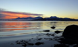 Midday twilight on Kvaløya in winter
 -
 View of the Ersfjorden
 -
 Rekvik village on Kvaløya
 -
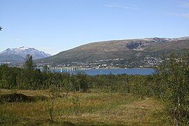
 Tromsøya (right) and Kvaløya (left)
 -
 Rock carvings at Skavberget
 -
 Village of Kaldfjord
 -
 Kvaløysletta


.jpg)


See also
References
- Store norske leksikon (in Norwegian). Kunnskapsforlaget. Retrieved 2018-08-12.
- ^ Børstad, Sanna Drogset (2018-08-13). "Nå er det ikke lenger moskus på Ryøya" [There are No More Musk Oxen on Ryøya]. ITromsø (in Norwegian). Retrieved 2019-04-21.