
Lake Faguibine
| Lake Faguibine | ||
|---|---|---|
Primary inflows Niger River | | |
Lake Faguibine was a lake in
In 2021, Lake Figuibine was entirely dry.[1] A gas emanating from the dry ground destroys the remaining vegetation and renders the soil unfit for cultivation.
Lake Faguibine system
The lake forms part of a system of five interconnected low-lying depressions that fill to variable depths depending on the extent of the annual flood of the Niger River. Lake Faguibine is by far the largest of these depressions with an area of 590 km2.[2][3] The low annual rainfall in the area (less than 200 mm) only has a marginal effect on the water levels in the depressions.
The depressions are connected to the Niger River by two channels. The more southerly Kondi channel (64 km in length) branches from the Niger a few kilometers downstream of Diré[4] and then meanders across the Killi floodplain. The larger and more northerly Tassakane channel (104 km in length) branches from the Niger further downstream near Korioumé and then meanders across the Kessou floodplain. The two channels unite to form a single channel to the east of Goundam which after another 20 km flows into the southern end of Lake Télé.[5] Lake Télé is connected at its northern end to Lake Takara. Water flows out of the northern end of Lake Takara, across a rocky sill at Kamaïna and then turns west passing the village of Bintagoungou to reach Lake Faguibine.
Both Lake Télé and Lake Takara need to be completely filled before the water can flow over the sill at Kamaïna and begin to supply Lake Faguibine. In a similar manner two depressions to the east of Lake Faguibine (Lake Kamango and Lake Gouber) only start to fill once Lake Faguibine is full.[6] To completely fill the 590 km2 of Lake Faguibine requires about 4 km3 of water. This represents around 17 percent of the average discharge of the Niger (1970-1998) at Diré.[7]
The lake bed is very fertile and the ideal situation for the sedentary farmers is when the lake is only partially filled. This allows crops to be cultivated around the border of the lake and the growth of Echinochloa stagnina ("bourgou") in low-lying areas to provide dry season pasture. This regime requires much less water – only around 0.5 km3.[8]
River Niger and the annual flood
 Average monthly flow (m3/s) at the Diré hydrometric station over the period 1924-1992[9] |
The filling of Lake Faguibine with water from the Niger River is dependent on both the height of the annual flood and the free flow of water along the complex 170 kilometres (110 mi) route linking the lake to the river. The annual flood of the Niger River is a result of the heavy rainfall in
One of the major aims of a United Nations Sudano-Sahelian Office (UNSO) project (1986-1990) was to improve the connection of the Niger with Lake Faguibine and to cut some of the meanders of the Kondi channel. The project was interrupted by the
In 2006 the Government of Mali created the "Office pour la Mise en Valeur du système Faguibine" (OMVF) to maintain the channels and to stabilize the sand dunes by planting Euphorbia balsamifera and eucalyptus.[16]
Much of the vegetation that stabilized the dunes perished in the drought that started in the late 1970s. As a result, sand is blown and washed into the channels. The sill at Kamaïna is next to large dunes and is particularly vulnerable to the accumulation of sand. Starting in 2002, the local villages cooperated in removing the sand and since 2006 the efforts have been coordinated by the OMVF and supported by the World Food Program.[17] In October 2008, around a 1000 people worked for 6 days to clear the sand.[18]
In a project funded by the government of
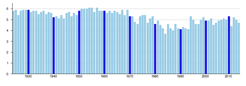
Annual maximum height (in meters) of the Niger River at the Diré hydrological station[21]
Notes
- ^ "Changement climatique au Mali : le désert engloutit le lac Faguibine, la population poussée à l'exode". Multimedia Newsroom of the International Committee of the Red Cross. 2021-09-28. Retrieved 2021-09-29.
- ^ Hamerlynck, Chiramba & Pardo 2009, p. 2
- ^ Map at a scale of 1: 500,000 that includes the Lake Faguibine system (PDF), Mali-Nord Programme, 2005.
- ^ Map at a scale of 1: 100,000 showing the Kondi and Tassakane channels (PDF), Mali-Nord Programme, 2007.
- ^ Hamerlynck, Chiramba & Pardo 2009, p. 14
- ^ Hamerlynck, Chiramba & Pardo 2009, p. 18
- ^ Hamerlynck, Chiramba & Pardo 2009, p. 20
- ^ Hamerlynck, Chiramba & Pardo 2009, p. 20
- ^ Composite Runoff Fields V 1.0: Diré, University of New Hampshire/Global Runoff Data Center, retrieved 15 Jan 2011.
- ^ Zwarts, Cissé & Diallo 2005, pp. 18–19.
- ^ Hamerlynck, Chiramba & Pardo 2009, p. 21.
- ^ Zwarts & Bakary 2005, p. 85.
- ^ Zwarts, Cissé & Diallo 2005, pp. 22–23.
- ^ Zwarts, Cissé & Diallo 2005, pp. 27–28.
- ^ Hamerlynck, Chiramba & Pardo 2009, pp. 15–16.
- ^ Hamerlynck, Chiramba & Pardo 2009, p. 34.
- ^ Mali: Restoring Lake In Desert, Farmers Keep Hunger Away, World Food Program, 2009, archived from the original on 2009-12-26, retrieved 2009-12-28.
- ^ Hamerlynck, Chiramba & Pardo 2009, p. 18.
- ^ Rehabilitating Lake Faguibine Ecosystem: Project factsheet (PDF), United Nations Environment Program, archived from the original (PDF) on 2009-12-22, retrieved 2009-12-21.
- ^ Hamerlynck, Chiramba & Pardo 2009, p. 5.
- ^ Hydrological Information System, Diré, Centre Régional du Projet NIGER-HYCOS, retrieved 19 June 2015.
References
- Hamerlynck, O.; Chiramba, T.; Pardo, M. (2009), Gestion des écosystèmes du Faguibine (Mali) pour le bien‐être humain : adaptation aux changements climatiques et apaisement des conflits. Version 5 April 2009 (in French), United Nations Environment Program, archived from the originalon 25 July 2011, retrieved 2009-12-20.
- Zwarts, Leo; Cissé, Navon; Diallo, Mori (2005), "Hydrology of the Upper Niger", in Zwarts, Leo; van Beukering, Pieter; Kone, Bakary; et al. (eds.), The Niger, a lifeline: Effective water management in the Upper Niger Basin (PDF), Veenwouden, the Netherlands: Altenburg & Wymenga, pp. 15–39, ISBN 90-807150-6-9, archived from the original (PDF) on 2011-07-24, retrieved 2011-01-17. Also published in French with the title Le Niger: une Artère vitale. Gestion efficace de l’eau dans le bassin du Haut Niger.
- Zwarts, Leo; Bakary, Kone (2005), "People in the Inner Niger Delta", in Zwarts, Leo; van Beukering, Pieter; Kone, Bakary; et al. (eds.), The Niger, a lifeline: Effective water management in the Upper Niger Basin (PDF), Veenwouden, the Netherlands: Altenburg & Wymenga, pp. 79–86, ISBN 90-807150-6-9, archived from the original(PDF) on 2011-07-24, retrieved 2011-01-17.
Further reading
- Chudeau, René (1918), "La dépression du Faguibine", .
External links
- Drying of Lake Faguibine at NASA Earth Observatory
- Ecosystem Management for improved Human Well-Being in the Lake Faguibine System: conflict mitigation and adaptation to climate change (PDF), United Nations Environment Program, archived from the original (PDF) on 2012-09-15, retrieved 2009-12-20. An incomplete draft dated 02-10-2008 of an English version of the Hamerlynck UNEP document.
- Mali-Nord: a German foreign aid program funded by Kreditanstalt für Wiederaufbau (KfW) that has been operating in northern Mali since 1994. Mostly in German but a few files in French and one in English by Andrew Dillon: Measuring the Programme Mali-Nord’s Impact.