
Lake Imandra
| Lake Imandra | |
|---|---|
Niva River | |
| Basin countries | Russia |
| Surface area | 876 km2 (338 sq mi) |
| Max. depth | 67 m (220 ft) |
| Surface elevation | 127 m (417 ft) |
| Frozen | Winter |
| Islands | Erm Island |
Imandra (
Niva River. The lake is known for the transparency of its water and its abundance of fish
.
Towns on or near the lake
The town of
cross-country skiers
.
Niva River
a few kilometers below its outflow from the lake.
-
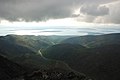 View on lake Imandra from the Khibiny Mountains
 -
 A section of the Monche Guba in Monchegorsk (running across the photo from right to left)
 -
 Satellite image


Presently, Lake Imandra is only used by local residents for recreational boating.
However, for several years in the 1930s, before the railway branch between Monchegorsk and the Leningrad-Murmansk mainline was built, Monchegorsk was connected to the rest of the country in summer by boat across Lake Imandra. Ferries from Monchegorsk would dock in Tik-Guba (today's Apatity), on the main rail line.[1]
Notes
- ^ M.P. Ilyina, "Этого забыть нельзя" (This cannot be forgotten), in "Спецпереселенцы в Хибинах : Спецпереселенцы и заключенные в истории освоения Хибин : (книга воспоминаний)" ('Special settlers' in the Khibins: Special settlers and convicts in the history of the developments of the Khibins). The Khibiny Branch of the Memorial Society, Apatity, 1997, p. 115