Lake Managua
| Lake Managua | |
|---|---|
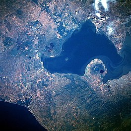
 1986 (north is to the left) | |
| Coordinates | 12°20′N 86°25′W / 12.333°N 86.417°W |
| Primary outflows | Tipitapa River |
| Basin countries | Nicaragua |
| Max. length | 65 km (40 mi) |
| Max. width | 25 km (16 mi) |
| Surface area | 1,024 km2 (395 sq mi) |
| Average depth | 9.5 m (31 ft) |
| Max. depth | 20 m (66 ft) |
| Surface elevation | 39 m (128 ft) |
| Islands | Momotombito |
| Settlements | Managua |
Lake Managua (
Islands
There are two uninhabited lake islands:
- Momotombito, a volcanic island. There is another nearby volcano, on the mainland: Momotombo.
- Isla Rosa, an islet
Floodings
The level of Lake Managua raises significantly during the periods of heavy rain. The highest water level was recorded during the flooding of 1933.[2]
The lake rose 3 metres (10 ft) in five days during Hurricane Mitch in 1998, destroying the homes of many who lived on its edge. An even higher flooding occurred in September/October 2010.[2] Since then, the city has prohibited residential use of the most flood-prone areas, those with the elevation below 42.76 meters above sea level.[2]
Pollution
Lake Managua has been described by some authors as "the most contaminated lake in Central America."[2] The lake has been severely polluted, mostly by decades of sewage being dumped into the lake.[3] The city sewers have drained into the lake since 1927.[2] It was only in 2009 that a modern wastewater treatment plant (built and operated by the British company Biwater) was opened in Managua, but even it treats only 40% of the city's wastewater.[2]
The lake today has no stable outlet, with only occasional floods to Lake Nicaragua through the Tipitapa River. Pollutants are thus concentrated.[4] Despite the pollution, some of the people of Managua still live along the lake's shores and eat the fish.[2]
In 2007 the
Wildlife
About 20 fish species still survive in Lake Managua.[2]
While joined to Lake Nicaragua, the bull sharks of that lake cannot migrate to Lake Managua due to a 12-foot-high (3.7 m) waterfall on the Tipitapa River.[4]
Gallery
References
- ^ "Nicarao".
- ^ a b c d e f g h Douglas Haynes, [The Lake at the Bottom of the Bottom]. VQR, Summer 2011
- ^ Hazel Plunkett. Nicaragua: A Guide to the People, Politics and Culture. Interlink Books, Dec 1, 2001. pg. 71
- ^ a b Thorson, Thomas B., "The Status of the Lake Nicaragua Shark: An Updated Appraisal" (1976). Investigations of the Ichthyofauna of Nicaraguan Lakes.Paper 41.


