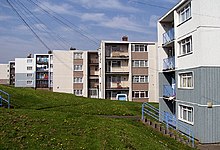
Lawrence Weston, Bristol
| Lawrence Weston | |
|---|---|
Avon and Somerset | |
| Fire | Avon |
| Ambulance | South Western |
Bristol North West | |

Lawrence Weston is a post-war housing estate in northwest Bristol, England, between Henbury and Shirehampton.
The estate is bounded in the east by the
Kingsweston
.
Lawrence Weston was originally a hamlet, a
Kings Weston
. Originally council owned, much of the housing stock is now in private hands.
There are two youth centres, a BMX track, a young people's shop called Juicy Blitz and a Youth Inclusion project. It has a community farm and a range of clubs and groups for young people.
Kings Weston House and Kings Weston Roman Villa both lie near the western end of the estate.
Lawrence Weston Moor
Lawrence Weston Moor is an 11.9 hectare
See also
- Kingsweston
References
- ^ Extract from National Gazetteer, 1868
- ^ "Lawrence Weston Moor". Reserves. Avon Wildlife Trust. Retrieved 19 December 2010.
- ^ "Lawrence Western Moor". Local Nature Reserves. Natural England. Retrieved 4 August 2013.
- ^ "Map of Lawrence Western Moor". Local Nature Reserves. Natural England. Retrieved 4 August 2013.
