
Leibis-Lichte Dam
| Leibis-Lichte Dam | |
|---|---|
Municip. Unterweissbach, Lichte Valley | |
| Coordinates | 50°36′3″N 11°10′24″E / 50.60083°N 11.17333°E |
| Construction began | 2002 |
| Opening date | 2005 |
| Dam and spillways | |
| Type of dam | Gravity dam |
| Height | 102.5 m (336 ft) |
| Length | 369 m (1,211 ft) |
| Width (crest) | 9 metres (30 ft) |
| Width (base) | 80.6 m (264 ft) |
| Dam volume | 13,500 m3 (480,000 cu ft) |
| Spillway capacity | 86.5 cubic metres per second (3,054.7 cu ft/s) |
| Reservoir | |
| Creates | 5.6 million cubic metres (0.198×10⁹ cu ft) |
| Total capacity | 32.4 million cubic metres (1.14×10⁹ cu ft) |
| Catchment area | 72 square kilometres (28 sq mi) |
| Surface area | 122 hectares (301 acres) |
| Maximum water depth | 91 metres (299 ft) |
| Power Station | |
| Installed capacity | 1 megawatt (1,300 hp) |
The Leibis-Lichte Dam (
Lichte River
as being the main inlet.
Construction
The Leibis-Lichte Dam was constructed in the time period from 2002 to September 2005.

Inside the formwork, heavy equipment was used to spread and compact the large quantities of concrete.[1] Mini excavators and graders put nearly 2,000 cubic metres (71,000 cu ft) of concrete each day into the formwork blocks. Giant cable cranes, reaching over the valley, moved the concrete across the site, with the transport containers holding up to 6 cubic metres (212 cu ft) of concrete.[1]

Pictures
-
 Leibis-Lichte Dam, 102.5 m high (336 ft)
 -
 Office building on top of the dam
 -
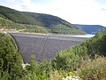
 View from the dam to the artificial lake, August 2009
 -
 Dam completed, August 2009
 -
 View from inside the waterside


See also
- List of reservoirs and dams in Germany
References
External links
![]() Media related to Talsperre Leibis-Lichte at Wikimedia Commons
Media related to Talsperre Leibis-Lichte at Wikimedia Commons
- Leibis-Lichte Dam on homepage of the Thuringian long-distance water supply (de: Tueringer Fernwasserversorgung
- Homepage (private) concerning the Leibis-Lichte Dam
- Pictures of the building site on baustellen-doku.info
| International | |
|---|---|
| National | |