
Leith Links

Leith Links (
Current uses
The west section of the park contains children's play areas, football pitches and, in the north-west corner, three public bowling greens and new tennis and
Previous uses
Historically the park contained a Victorian bandstand, a pond for model yachts, and was used for annual events such as pageants. Leith Races were held on Leith Sands at the edge of the original links.
History
During the
During the Siege of Leith in 1560, English and Scottish troops made use of the area to create siege trenches. Two mounds on Leith Links, known as "Giant's Brae" and "Lady Fyfe's Brae", identified on later maps as "Somerset's Battery" and "Pelham's Battery" respectively, are scheduled monuments as artillery mounds created for the siege in April 1560. However, a contemporary map at Petworth shows that Pelham's Battery was built on the slope to the south of Leith Links and Somerset's battery was located adjacent to the present Pilrig House. The tradition that these two batteries were on the Links goes no further back than Campbell's "History of Leith" published in 1827. Lent authority by the Ordnance Survey 1852, the identification saved the mounds in 1888 when several other hillocks were removed during landscaping.[3]
Bishop Couper was playing golf on Leith Links in 1619 when he had a vision. Charles I of England was playing golf on Leith Links in 1642 when he received news of the Irish rebellion. Games were frequently the subject of betting and Captain John Porteous bet 20 guineas in a match against Alexander Elphinstone (d.1732), brother of Lord Balmerino in 1724.[4]
The same Alexander Elphinstone, who had riches but no employment, appears in a more dramatic event on 23 December 1729 when he challenged Lt Swift of Lord Cardigan's Regiment to a duel (with swords) on Leith Links. Elphinstone mortally wounded Swift.[5]
Leith Links is famous in the
It is believed the first international golf contest took place at the links, when the Duke of Albany played two English courtiers for national claim to the game of golf. The game resulted in the construction of Golfers Land on the Royal Mile by the Duke's partner, the Edinburgh cobbler John Paterson.[10]
The entire area was only formalised as a public park (as opposed to a public open space) in 1888 as part of the Leith Improvement Plan. At this time the area was levelled (other than the two surmised gun batteries) and planted with trees along its perimeter and several paths dividing the area. Cast iron railings enclosing the entire area were erected but these were removed during World War II as part of the war effort. Following the creation of the park, golf was discouraged, but was not officially banned here until 1905.
As part of the remodelling in 1888 various discoveries were made: foremost of these were two burial areas at either end of the Links. That to the extreme west, in the triangle of land isolated by Wellington Place, was surmised to be burial pits from an outbreak of the plague which affected Leith in the middle of the 17th century.[11]
The Plague of 1645

The plague which struck Leith in 1645 was only one of many periodic outbreaks of plague that occurred in Edinburgh and Leith between the 14th and 17th centuries. The historian Christopher Smout believes that the 1645 epidemic, which occurred at a time when warring armies were on the march, probably resulted from the spread of typhus.[12] It may have been carried north by Scottish soldiers present at the Siege of Newcastle where plague was reported after the town's surrender to General Leslie on 19 October 1644.[13]: 9
.JPG)
The records of
An entry for 17 July, when it was "ordained to provyd some wemen to help to fill ye cairts [of muck and refuse]" suggests there was a shortage of able-bodied men for cleansing the town. The women were drawn mainly from the infected, although female prisoners were also put to work.[13]: 15 The bailies and quartermasters visited the huts daily, distributing to each person three half-loaves of bread, a Scotch pint of ale and any other necessities. A special storehouse manned by two storekeepers was built to accommodate the provisions. The huts were cleaned by "foul clengeris" who wore a distinctive uniform described as "ane joupe [coat] of blak with a St. Andrew's Cross of quhyte clayth sewit about with the sam for designing and knawing of thame be utheris".[13]: 18 Clothing was disinfected by boiling in large iron cauldrons. Clothing that could not be so treated was burned, or placed in kilns to subject it to the smoke and heat of burning heather and whins.[13]: 19 One such kiln in the form of a converted castle doocot still stands at Lochend, about a mile south of the Links. Apart from a few exceptions in South Leith Kirkyard, the dead were buried on the Links, wrapped in the coarse blankets in which they had lain. After the outbreak had abated Aldinstone, a fortunate survivor, reported to the Session on 3 February 1646 that the number of fatalities for South Leith amounted to 2,421 (out of an estimated population in excess of 4,000), for Restalrig 160 and Craigend (i.e. Calton) 155, making a total of 2,736 for the whole parish. No records have survived in respect of the smaller parish of North Leith.[13]: 20–21
During works in the playground of St Mary's RC Primary School (on the north edge of Leith Links) the remains of 79 bodies were found, thought to be victims of the plague. They were interred in Rosebank Cemetery in 2018 and marked with a memorial plaque.
Surrounding development


Leith Links originally lay wholly to the east of medieval Leith. Only from 1770 onwards did local law permit building outwith the old town wall. The first development was on the extreme north-west corner (now Queen Charlotte Street) where three roughly identical villas were constructed around 1775. From then various edges of the Links were gradually developed, those to the south-east being largely from the early 19th century and particularly grand. These houses, as well as both the eastern and western sections of the Links, feature prominently in the Leith-based political crime novel - Kertamen by Mauro Martone.[15] The majority of buildings facing the Links are the first building on their site and most date from the 19th century. A group of colony houses are located to the south of the Links.
Allotment gardens were created on the north-east edge during World War II and still remain. The industrial hinterland here originally held ropeworks and cooperages but for most of the 20th century operated as a bottling plant for United Distillers until they vacated the site around 2005.
Seafield Cemetery was developed at the extreme east end of Leith Links in 1887. Seafield Crematorium stands at the far east side of the cemetery, with a separate access from Seafield Road. It opened in 1939.
The west side of the Links is dominated by the two large school buildings: Leith Primary and the former Leith Academy building by Reid and Forbes (now converted to housing).
Monuments
- Statue of John Rattray playing golf - on north edge
- Memorial cairn to the founding of golf on the site - on west edge
- Memorials plaques on Giant's Brae and Lady Fyfe's Brae explaining their military significance.
Botanical
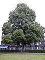
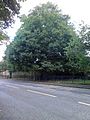
Leith Links is noteworthy for its high concentration of mature
-
 Ulmus × hollandica 'Viminalis', Vanburgh Place, Leith Links, 2016
 -
 Ulmus minor 'Rueppellii', Links Place, Leith Links, 2016
 -
 Convex-leaved field elm cultivar, Duncan Place, Leith Links, 2016
 -
 Ulmus × hollandica 'Dauvessei', Claremont Park, Leith Links, 2016
 -
 Blandford Elm, Hermitage Place, Leith Links, 2016
 -
 Dutch elm cultivar, Hermitage Place, Leith Links, 2016
 -
 Unidentified elm, south corner of Leith Links, 2016
.jpg)
.jpg)
.jpg)
.jpg)
.jpg)
.jpg)
.jpg)
References
- ^ Leith Festival | Gala Day: 9 June 2012
- ^ Knox, John, History of The Reformation, Bannatyne Club, vol. 2 (1846), 377: CSP Scotland, vol. 1 (1898), 231-2, French copy dated 23 July 1559.
- ^ Harris, Stuart, 'The Fortifications and Siege of Leith', in PSAS, vol. 121, (1991), pp. 361–62 & fn. 21
- ^ Cassell's Old and New Edinburgh; vol. 6, p. 260
- ^ Cassell's Old and New Edinburgh; vol. 6, p. 263
- ^ "Foundation of world's first golf club 1744". Retrieved 16 June 2014.
- ^ Chambers 1996, p. 320.
- ^ Chambers 1996, p. 321.
- ^ The Life and Times of Leith, by James Marshall
- ^ "Golfer's Land".
- ^ Society of Antiquaries of Scotland, 1888 records, National Library of Scotland
- ^ T C Smout, A History Of The Scottish People, Collins 1969, p.164
- ^ a b c d e f Tait, H P (1966). "Two Notable Epidemics In Edinburgh and Leith". The Book of the Old Edinburgh Club. xxxii.
- ^ D Robertson (ed.), South Leith Records, Edinburgh 1911
- ^ "Kertamen". 28 November 2017.
- ^ Ian Nimmo, Edinburgh's Green Heritage: Discovering the Capital's Parks, Woodlands and Wildlife (Edinburgh 1996)
Bibliography
- ISBN 0550735208.