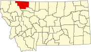
Little Browning, Montana
Appearance
Little Browning, Montana | ||
|---|---|---|
FIPS code 30-43835 | | |
| GNIS feature ID | 2583824[2] | |
Little Browning is a
2010 census.[3]
Demographics
| Census | Pop. | Note | %± |
|---|---|---|---|
| 2020 | 218 | — | |
| U.S. Decennial Census[4] | |||
Education
The area school district is Cut Bank Public Schools,[5] with its components being Cut Bank Elementary School District and Cut Bank High School District.[6]
References
- ^ "ArcGIS REST Services Directory". United States Census Bureau. Retrieved September 5, 2022.
- ^ a b U.S. Geological Survey Geographic Names Information System: Little Browning, Montana
- ^ "U.S. Census website". United States Census Bureau. Retrieved May 14, 2011.
- ^ "Census of Population and Housing". Census.gov. Retrieved June 4, 2016.
- ^ "Directory of Montana Schools". Montana Office of Public Instruction. March 13, 2024. p. 121-122/319. Retrieved March 13, 2024.
- U.S. Census Bureau. p. 3 (PDF p. 4/6). Retrieved March 13, 2024. - Text list

