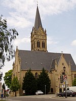
Lucka
Lucka | |
|---|---|
 Wettinerbrunnen, erected in memory of the 1307 battle of Lucka | |
Location of Lucka within Altenburger Land district  | |
Altenburger Land | |
| Subdivisions | 3 |
| Government | |
| • Mayor (2019–25) | Kathrin Backmann-Eichhorn[1] |
| Area | |
| • Total | 12.99 km2 (5.02 sq mi) |
| Elevation | 150 m (490 ft) |
| Population (2022-12-31)[2] | |
| • Total | 3,530 |
| • Density | 270/km2 (700/sq mi) |
| Time zone | UTC+01:00 (CET) |
| • Summer (DST) | UTC+02:00 (CEST) |
| Postal codes | 04613 |
| Dialling codes | 034492 |
| Vehicle registration | ABG |
| Website | www.lucka.de |
Lucka is a town in the
landkreis of Altenburger Land
.
History
The settlement of the area around Lucka occurred in the early
Duchy of Saxe-Altenburg. From 1952 to 1990, it was part of the Bezirk Leipzig of East Germany
.
International relations
Lucka is
twinned
with:
Town Division
Lucka is divided into three parts: the town itself, Breitenhain and Prößdorf.
Personalities
- Friedrich August Belcke – trombonist
- Otto Engert — a Communist politician (b. in Prößdorf)
- Erika Zuchold - World Champion and Olympic Medalist in Gymnastics

References
- ^ Gewählte Bürgermeister - aktuelle Landesübersicht, Freistaat Thüringen, accessed 14 July 2021.
- Thüringer Landesamt für Statistik. June 2023.
- The information in this article is based on and/or translated from that found in its German equivalent.


