Manfuhah
This article needs additional citations for verification. (May 2021) |


Manfuha (
Etymology
Manfuhah derives from the
History
According to
In the late 18th century, Manfuha fell under the rule of the energetic ruler of Riyadh,
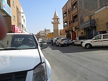
As the neighbouring Saudi capital expanded exponentially in the 20th century, fueled by the country's oil wealth, the walls of both Manfuha and Riyadh were torn down, and Manfuha was quickly swallowed in whole by the growing metropolis. Today, Manfuha is among the poorer districts of Riyadh as most of its original inhabitants have left to newer districts of the capital. Some of the town's old mud-brick buildings remain, as well as an ancient observation tower. A wide avenue cuts through the centre of Manfuha, named Al-A'sha Street, after its most famous son.[citation needed]
Manfuha is now a neighbourhood in southern Riyadh.[3]
References
- ^ "أحياء الرياض القديمة.."التاريخ" حفظ الأسماء و"الحاضر" أهمل الأماكن!". www.alriyadh.com (in Arabic). 4 June 2010. Retrieved 24 January 2023.
- Mu'jam Al-Buldan
- ^ "Manfuha Weather, Ar Riyad, SA". World Weather Online. Retrieved 27 June 2021.
