Maribondo
You can help expand this article with text translated from the corresponding article in Portuguese. (September 2023) Click [show] for important translation instructions.
|
Maribondo | |
|---|---|
 | |
| Established | 24 August 1962 |
| Area | |
| • Total | 171.279 km2 (66.131 sq mi) |
| Population | |
| • Total | 13,193 |
| • Density | 77/km2 (200/sq mi) |
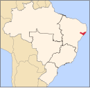
09°34′37″S 36°18′18″W / 9.57694°S 36.30500°W Maribondo is a
History
Small place called Poço da Caatinga was established in 1905, 18 kilometers away from Anadia, and had this name for having a well of clear water located between Inga and Cassia fistula trees. In the middle of the vegetation a large house of Wasps (maribondos) was formed, and the place became called Poço da Casa de Maribondos. Among farms, José Sapucaia de Araújo's was the one that developed the most, with the installation of the first cotton steamer in 1910. In 1913, the Azevedo family arrived in the region and, soon after, José Xavier de Azevedo installed the first fair, destroyed by the Anadia municipal guard.
The history of the town recognizes as its founder João Antônio dos Santos, who bought a large farm in 1919, building a house and the first grocery store in the town, opening also a small fabric store.
In 1930, with 45 residents, Maribondo served as a rest stop for travelers coming to the capital or going to the interior. In 1947 a new fair was established. Governor Silvestre Péricles, created the Rural School in 1948, and the first church in 1950. The BR-316 highway also gave an important boost to the development of the town, leading a group to work for autonomy. In 1962, the district was emancipated from Anadia.[3]
References
- ^ IBGE 2020
- ^ IBGE - "Archived copy". Archived from the original on 2007-01-09. Retrieved 2007-01-09.
{{cite web}}: CS1 maint: archived copy as title (link) - ^ "História Maribondo". cidades.ibge.gov.br. Retrieved 2023-06-07.

