
Marston Road

Marston Road is a road in the east of
Headley Way at the northern end. To the north is the suburb of Northway. The road is designated the B4150
but this is not shown on signs.
The striking new building for the Oxford Centre for Islamic Studies with its prominent dome and minaret is located on the west side of Marston Road, next to land owned by Magdalen College. There are also Oxford college sport's grounds and a lane linking to Mesopotamia and the University Parks.[1]
St Clement's Church[2] is at the southern end of the road. The original St Clement's Church was located at The Plain near Magdalen Bridge but this was demolished in 1829, after the new church had been built in 1827–28.
Marston United Reformed Church[3] is at 352 Marston Road.[4] The Rivers of Life evangelical church meet here.[5]
Milham Ford School
In the 1930s,
Harberton Mead, south of Jack Straw's Lane.[6][7] It opened in 1938, became a girls' grammar school in 1944, and a girls' comprehensive school in 1974. The school was closed in 2003 and was sold. In 2004, the School of Health Care of Oxford Brookes University started to use the building.[8] The green area between the school and Marston Road is now Milham Ford Nature Park.[9]
Gallery
-
 The Oxford Centre for Islamic Studies on Marston Road.
 -
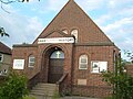 The United Reformed Church at 352 Marston Road.
 -
 View of the former Milham Ford School building on Marston Road, now used by Oxford Brookes University.


References
- ^ ISBN 0-333-39917-X.
- ^ St Clement's Church website.
- ^ Marston United Reformed Church website
- ^ "Marston United Reformed Church: How to Find us". Archived from the original on 27 October 2007. Retrieved 21 January 2008.
- ^ "Rivers of Life - Meetings & Directions". Archived from the original on 8 October 2007. Retrieved 21 January 2008.
- ^ Jack Straw's Lane Archived 2010-07-07 at the Wayback Machine.
- ^ Milham Ford School - Photographs 2002-2011 by Marilyn Cox.
- ^ Marston Road site, Oxford Brookes University.
- ^ Cox, Marilyn. "History of Milham Ford Nature Park". Archived from the original on 23 October 2012. Retrieved 21 October 2012.