
Matadi
Matadi | |
|---|---|
Provincial capital and UTC+1 (West Africa Time ) |
Matadi is the chief sea port of the Democratic Republic of the Congo and the capital of the Kongo Central province, adjacent to the border with Angola. It had a population of 245,862 (2004). Matadi is situated on the left bank of the Congo River, 148 km (92 mi) from the mouth and 8 km (5.0 mi) below the last navigable point before the rapids that make the river impassable for a long stretch upriver.
History

Matadi was near the site of the state of Vungu, which was first mentioned in 1535 [4] and was said to be destroyed in 1624.
Matadi itself was founded by
Culture
The word Matadi means
Climate
Matadi has a relatively dry tropical savanna climate (Köppen Aw) with a lengthy dry season from June to September due to the northerly extension of the cold, foggy Benguela Current.
| Climate data for Matadi | |||||||||||||
|---|---|---|---|---|---|---|---|---|---|---|---|---|---|
| Month | Jan | Feb | Mar | Apr | May | Jun | Jul | Aug | Sep | Oct | Nov | Dec | Year |
| Mean daily maximum °C (°F) | 33 (91) |
33 (92) |
34 (94) |
34 (93) |
33 (91) |
30 (86) |
28 (83) |
29 (84) |
30 (86) |
32 (90) |
33 (91) |
32 (90) |
32 (89) |
| Mean daily minimum °C (°F) | 24 (76) |
24 (76) |
24 (76) |
24 (76) |
24 (75) |
22 (71) |
20 (68) |
21 (69) |
22 (72) |
24 (75) |
24 (75) |
24 (75) |
23 (74) |
| Average rainfall cm (inches) | 13 (5) |
11 (4.3) |
17 (6.6) |
19 (7.4) |
6.1 (2.4) |
0.25 (0.1) |
0.25 (0.1) |
0.25 (0.1) |
0.76 (0.3) |
2.8 (1.1) |
17 (6.7) |
15 (5.8) |
102.41 (39.9) |
| Source: Weatherbase[6] | |||||||||||||
Infrastructure

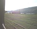
.jpg)
The mouth of the Congo forms one of Africa's largest harbours. In addition to Matadi, which is the furthest upriver, three ports are located within it, the others being
In Matadi there is the famous Matadi Bridge, the only one along the entire lower and middle reaches of the huge Congo River. Therefore, the main transcontinental flow of cars from the vast northwestern part of Africa to the south of the African continent passes through Matadi.
Matadi Bridge, a suspension bridge 722 m- long with a main span of 520 m, built in 1983, crosses the river just south of Matadi, carrying the main road linking Kinshasa to the coast. After passing through Matadi and over the bridge, it continues to Boma,
A power station on the M'pozo River supplies power to Matadi.[citation needed]
Port

The maximum draft of the port is 8.2m.[7] The Navy of the Democratic Republic of the Congo maintains one operational command at the port.
Currently, larger ships are required to transfer cargo to smaller vessels in the Republic of Congo's Pointe-Noire port. For this reason, the development of a deep-sea port at Port Banana was begun in 2022.[8]
Media
La Cité africaine de Matadi is a newspaper published in French in Matadi.[9]
In Belgium, a small garden city in the Heverlee suburb of Leuven was named after Matadi in the 1920s.[10]
Gallery
-
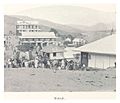 Matadi, 1899
 -
 The market, 1899
 -
 A corner market in Matadi, 1899
 -
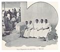 Women at the market in Matadi, 1899
 -
 The market, 1899
 -
 The houses of Matadi, 1899
 -
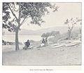 The surroundings of Matadi, 1899
 -
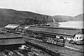 Matadi port, circa 1942
 -
 Full Congo River at Matadi and the first rapids
 -
 Arrival at Matadi station
 -
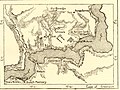 Map of Matadi and Vivi around 1890
 -
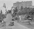 Matadi in 1930s


See also
References
- ^ "Kongo Central : le nouveau maire s'engage à matérialiser la vision du Chef de l'État" (in French). L’Agence congolaise de presse (ACP). 6 January 2023. Retrieved 7 January 2023.
- ^ "caid.cd/index.php/donnees-par-villes/ville-de-matadi/?domaine=fiche". Archived from the original on 30 November 2020.
- ^ "Matadi, Democratic Republic of the Congo Population (2022) - Population Stat". populationstat.com. Retrieved 2022-08-19.
- ^ Afonso I to the Pope Paulo III, 21 February 1535 in Antonio Brasio, ed. Monumenta Missionaria Africana (15 vols, Lisbon 1952-88) 2: 38.
- ^ History of architecture: city, architecture and
colonial space in Matadi and Lubumbashi, Sofie Boonen, "Archived copy" (PDF). Archived from the original (PDF) on 2014-07-14. Retrieved 2014-07-11.
{{cite web}}: CS1 maint: archived copy as title (link) - ^ "Weatherbase: Historical Weather for Matadi, Democratic Republic of the Congo". Weatherbase. 2011. Retrieved on November 24, 2011.
- ^ "E-ships.net".
- ^ "Construction of Banana Port begins in Congo". Ships & Ports.
- ^ University, © Stanford; Stanford; California 94305. "African collections". Stanford Libraries. Retrieved 2022-08-19.
{{cite web}}: CS1 maint: numeric names: authors list (link) - ^ Verbinnen, Liam (15 April 2021). "Matadi Leuven: historische tuinwijk met bruisende gemeenschap – 21bis". 21bis. Retrieved 27 March 2023.
Further reading
- Lagae, J. (2019). ""Pour Matadi la question [de la ségrégation] est encore plus grave qu'ailleurs": The Making and Shaping of a Congolese Port City during the Interwar Years". In Vanderlinden, J. (ed.). The Belgian Congo between the Two World Wars. Brussels: Royal Academy of Overseas Sciences. pp. 129–158. ISBN 9789075652628.
External links
Capitals of the provinces of the Democratic Republic of the Congo | ||
|---|---|---|
|  | |
Provinces are shown between brackets | ||
| Cities | |
|---|---|
| Territories |
|
| Populated places | |
| Other | |
| International | |
|---|---|
| National | |